Home > Asia > Israel > Maps
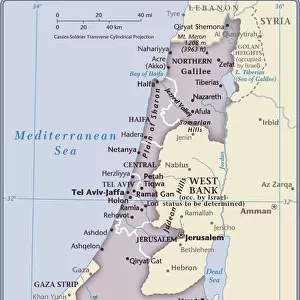
Map of Israel

![]()
Wall Art and Photo Gifts from Universal Images Group (UIG)
Map of Israel
Universal Images Group (UIG) manages distribution for many leading specialist agencies worldwide
Media ID 9539833
© Dorling Kindersley/UIG
Atlas Country Geography Israel
FEATURES IN THESE COLLECTIONS
> Universal Images Group (UIG)
> Illustrations
> Illustrations 1
EDITORS COMMENTS
This print showcases the intricate and detailed "Map of Israel" created by renowned cartography experts, Dorling Kindersley. With its vibrant colors and impeccable illustration, this map offers a comprehensive overview of the country's geography. From the lush green landscapes to the sprawling urban centers, every aspect is beautifully depicted. The Map of Israel serves as an invaluable tool for both travelers and enthusiasts alike. Whether you're planning an adventurous journey or simply curious about this ancient land's topography, this print provides a wealth of information at your fingertips. It highlights key landmarks such as Jerusalem's iconic Old City with its sacred sites like the Western Wall and Dome of the Rock. As you explore further into this visual masterpiece, you'll discover other significant cities like Tel Aviv, Haifa, and Eilat along with their respective geographical features. The map also outlines important bodies of water including the Mediterranean Sea to the west and the Dead Sea to the east – known for its unique salt concentration that allows swimmers to effortlessly float on its surface. With Dorling Kindersley's expertise in cartography evident throughout every inch of this artwork, it is no wonder why Universal Images Group (UIG) has chosen to showcase it in all its glory. This print not only captures Israel’s diverse landscape but also celebrates artistry in mapping techniques – making it a must-have addition for any travel enthusiast or lover of beautiful illustrations.
MADE IN AUSTRALIA
Safe Shipping with 30 Day Money Back Guarantee
FREE PERSONALISATION*
We are proud to offer a range of customisation features including Personalised Captions, Color Filters and Picture Zoom Tools
SECURE PAYMENTS
We happily accept a wide range of payment options so you can pay for the things you need in the way that is most convenient for you
* Options may vary by product and licensing agreement. Zoomed Pictures can be adjusted in the Cart.