Home > Europe > Italy > Molise > Campobasso
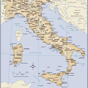
Region of Molise, Italy, Relief Map

![]()
Wall Art and Photo Gifts from Universal Images Group (UIG)
Region of Molise, Italy, Relief Map
Relief map of the region of Molise, Italy. This image was compiled from data acquired by LANDSAT 5 & 7 satellites combined with elevation data
Universal Images Group (UIG) manages distribution for many leading specialist agencies worldwide
Media ID 9619029
© Planet Observer/UIG
Coastline Molise Region Relief Map Shore Campobasso Satellite View
FEATURES IN THESE COLLECTIONS
> Europe
> Italy
> Molise
> Campobasso
> Universal Images Group (UIG)
> Universal Images Group
> Satellite and Aerial
> Planet Observer 4
EDITORS COMMENTS
This stunning print showcases the mesmerizing topography of the region of Molise, Italy. With its vibrant colors and intricate details, it offers a unique perspective on this beautiful part of Europe. The relief map was created by combining data acquired from LANDSAT 5 & 7 satellites with elevation information, resulting in a comprehensive representation of the region's physical geography. The image captures Molise's diverse landscape, ranging from rolling hills to rugged mountains and picturesque coastlines. The horizontal composition allows for an immersive viewing experience, as if one is soaring above this enchanting Italian region. No people are present in the photograph, emphasizing the untouched nature and tranquility that can be found here. Molise is known for its rich history and cultural heritage, with Campobasso being its capital city. This relief map not only serves as a visual delight but also provides valuable cartographic insights into the area's geographical features. Whether you are an avid traveler or simply fascinated by maps and topography, this print will surely captivate your imagination
MADE IN AUSTRALIA
Safe Shipping with 30 Day Money Back Guarantee
FREE PERSONALISATION*
We are proud to offer a range of customisation features including Personalised Captions, Color Filters and Picture Zoom Tools
SECURE PAYMENTS
We happily accept a wide range of payment options so you can pay for the things you need in the way that is most convenient for you
* Options may vary by product and licensing agreement. Zoomed Pictures can be adjusted in the Cart.