Home > Aerial Photography > Africa
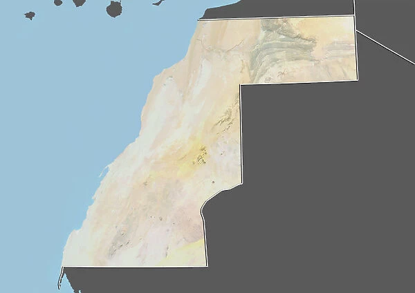
Western Sahara, Relief Map with Border and Mask
![]()

Wall Art and Photo Gifts from Universal Images Group (UIG)
Western Sahara, Relief Map with Border and Mask
Relief map of Western Sahara (with border and mask). This image was compiled from data acquired by landsat 5 & 7 satellites combined with elevation data
Universal Images Group (UIG) manages distribution for many leading specialist agencies worldwide
Media ID 9618711
© Planet Observer/UIG
Africa Coastline Desert Relief Map Sahara Shore Satellite View Western Sahara
FEATURES IN THESE COLLECTIONS
> Africa
> Western Sahara
> Maps
> Universal Images Group (UIG)
> Universal Images Group
> Satellite and Aerial
> Planet Observer 4
EDITORS COMMENTS
This print showcases the mesmerizing landscape of Western Sahara, a vast desert region in Africa. The image presents a relief map of the area, complete with borders and a mask, created using data acquired by Landsat 5 & 7 satellites combined with elevation information. The topography depicted in this photograph is truly awe-inspiring. With its intricate patterns and varying elevations, it offers an intriguing glimpse into the physical geography of Western Sahara. From rolling sand dunes to rocky terrains, every detail is beautifully captured. The horizontal composition allows for an immersive viewing experience, as your eyes wander across the expansive coastline that stretches along the edge of this arid land. The absence of people enhances the sense of solitude and highlights nature's dominance over this remote location. Cartography enthusiasts will appreciate how this image seamlessly blends scientific data with artistic representation. The color palette chosen adds depth and dimension to the relief map while maintaining accuracy. Whether you are fascinated by satellite views or simply drawn to stunning landscapes, this print from Universal Images Group (UIG) will undoubtedly captivate your imagination. It serves as a reminder of both Earth's remarkable beauty and our ability to explore and understand it through advanced technology like satellite imagery.
MADE IN AUSTRALIA
Safe Shipping with 30 Day Money Back Guarantee
FREE PERSONALISATION*
We are proud to offer a range of customisation features including Personalised Captions, Color Filters and Picture Zoom Tools
SECURE PAYMENTS
We happily accept a wide range of payment options so you can pay for the things you need in the way that is most convenient for you
* Options may vary by product and licensing agreement. Zoomed Pictures can be adjusted in the Cart.

