Home > Europe > France > Canton > Bas Rhin
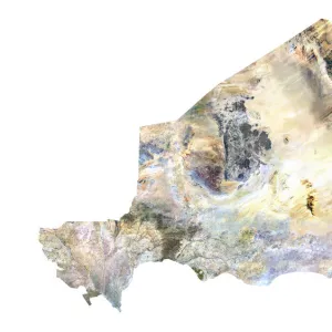
French Guiana, Relief Map

![]()
Wall Art and Photo Gifts from Universal Images Group (UIG)
French Guiana, Relief Map
Relief map of French Guiana in South America with country borders. This map was processed from elevation data
Universal Images Group (UIG) manages distribution for many leading specialist agencies worldwide
Media ID 9615691
© Planet Observer
Alsace Bas Rhin Geographical Border Relief Map Satellite View
FEATURES IN THESE COLLECTIONS
> Aerial Photography
> America
> Europe
> France
> Canton
> Bas Rhin
> Europe
> France
> Canton
> Rhin
> South America
> French Guiana
> Maps
> Universal Images Group (UIG)
> Universal Images Group
> Satellite and Aerial
> Planet Observer 6
EDITORS COMMENTS
This stunning print showcases the intricate and captivating relief map of French Guiana, a mesmerizing region nestled in South America. With its vibrant colors and detailed topography, this image allows us to explore the diverse landscapes that make up this unique territory. The map was meticulously processed from elevation data, providing an accurate representation of the country borders within French Guiana. As we gaze upon this photograph, we are transported into a world where physical geography takes center stage. From lush rainforests to winding rivers and majestic mountains, every contour on this relief map tells a story of nature's grandeur. The satellite view captured here offers us a bird's-eye perspective of French Guiana's breathtaking beauty. With no people in sight, we can fully immerse ourselves in the exploration of this land without any distractions. This print serves as an invaluable tool for cartographers and geographers alike who seek to understand the geographical borders that shape our world. The Universal Images Group (UIG) has once again delivered an exceptional piece of photography that captures not only France's Alsace region but also provides us with a glimpse into Europe's vertical landscapes. It is important to note that this photo should not be used for commercial purposes; instead, let it serve as an inspiration for those who appreciate the wonders of our planet’s natural formations.
MADE IN AUSTRALIA
Safe Shipping with 30 Day Money Back Guarantee
FREE PERSONALISATION*
We are proud to offer a range of customisation features including Personalised Captions, Color Filters and Picture Zoom Tools
SECURE PAYMENTS
We happily accept a wide range of payment options so you can pay for the things you need in the way that is most convenient for you
* Options may vary by product and licensing agreement. Zoomed Pictures can be adjusted in the Cart.