Home > Europe > France > Canton > Bas Rhin
Jigsaw Puzzle : Western Sahara, Satellite Image


![]()
Jigsaw Puzzles from Universal Images Group (UIG)
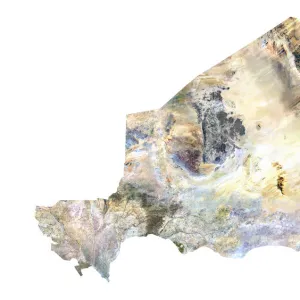
Western Sahara, Satellite Image
Satellite view of Western Sahara. This image was compiled from data acquired by LANDSAT satellite
Universal Images Group (UIG) manages distribution for many leading specialist agencies worldwide
Media ID 9615353
© Planet Observer
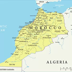
Alsace Bas Rhin Geographical Border Relief Map Satellite View
Jigsaw Puzzle (500 Pieces)
Discover the wonders of our planet with Media Storehouse's Jigsaw Puzzles. Our latest addition to the collection is a captivating Satellite Image of Western Sahara. This intricately designed puzzle, featuring a stunning satellite view of Western Sahara compiled from data acquired by LANDSAT satellite, is a must-have for puzzle enthusiasts and geography buffs alike. Immerse yourself in the intricacies of the desert landscape, and experience the satisfaction of piecing together this detailed and beautiful jigsaw puzzle. Explore the world from a new perspective with Media Storehouse.
500 piece puzzles are custom made in Australia and hand-finished on 100% recycled 1.6mm thick laminated puzzle boards. There is a level of repetition in jigsaw shapes with each matching piece away from its pair. The completed puzzle measures 40x51cm and is delivered packaged in an attractive presentation box specially designed to fit most mail slots with a unique magnetic lid
Jigsaw Puzzles are an ideal gift for any occasion
Estimated Product Size is 50.7cm x 40.3cm (20" x 15.9")
These are individually made so all sizes are approximate
Artwork printed orientated as per the preview above, with landscape (horizontal) or portrait (vertical) orientation to match the source image.
FEATURES IN THESE COLLECTIONS
> Africa
> Western Sahara
> Maps
> Africa
> Western Sahara
> Related Images
> Europe
> France
> Canton
> Bas Rhin
> Europe
> France
> Canton
> Rhin
> Universal Images Group (UIG)
> Universal Images Group
> Satellite and Aerial
> Planet Observer 6
EDITORS COMMENTS
This print showcases the mesmerizing beauty of Western Sahara from a satellite's perspective. Taken by the LANDSAT satellite, this image offers a unique and detailed view of the region's topography and physical geography. The vibrant colors in this photograph bring to life the diverse landscapes that make up Western Sahara. With no people present in the frame, one can truly appreciate the untouched nature of this vast territory. From rolling sand dunes to rugged mountain ranges, every inch of land tells a story waiting to be explored. The geographical borders are clearly defined, highlighting both its isolation and connection to neighboring regions. The aerial viewpoint allows us to grasp the sheer size and scale of Western Sahara, providing an awe-inspiring sense of its grandeur. As we gaze upon this vertical composition, it is impossible not to marvel at how such intricate details were captured from high above. This print serves as more than just an artistic representation; it also holds educational value for those interested in cartography or studying physical geography. It invites viewers on a visual journey through Western Sahara's natural wonders without ever leaving their seats. As we admire this remarkable piece from Universal Images Group (UIG), let us revel in its ability to transport us across continents and immerse ourselves in the breathtaking landscapes that our world has to offer.
MADE IN AUSTRALIA
Safe Shipping with 30 Day Money Back Guarantee
FREE PERSONALISATION*
We are proud to offer a range of customisation features including Personalised Captions, Color Filters and Picture Zoom Tools
SECURE PAYMENTS
We happily accept a wide range of payment options so you can pay for the things you need in the way that is most convenient for you
* Options may vary by product and licensing agreement. Zoomed Pictures can be adjusted in the Cart.