Home > Europe > United Kingdom > England > West Sussex > Crawley
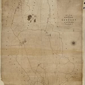
Crawley tithe map, 1839 (North section)
")
![]()
Wall Art and Photo Gifts from West Sussex County Council
Crawley tithe map, 1839 (North section)
By H. Walter, Windsor. 26.6 in. to 1 m. Part 1, 37 × 18; Part II, 37 × 26
Tithe Award Map Collection
West Sussex Record Office Ref No: TD/W155
West Sussex County Council Record Office contains a fascinating history of the county of West Sussex, England
Media ID 10702192
© West Sussex County Council - All Rights Reserved
1830s 19th Century Historical Mapping South Of England
FEATURES IN THESE COLLECTIONS
> Europe
> United Kingdom
> England
> Maps
> Europe
> United Kingdom
> England
> Sussex
> Crawley
> Europe
> United Kingdom
> England
> West Sussex
> Crawley
> Maps and Charts
> Early Maps
> West Sussex County Council
> West Sussex Record Office
> Tithe Award Maps, 1808-1859
EDITORS COMMENTS
This print showcases the historical Crawley tithe map from 1839, specifically focusing on its north section. Created by H. Walter of Windsor, this meticulously detailed map offers a fascinating glimpse into the past, providing valuable insights into land ownership and usage during the 19th century in the south of England. Measuring an impressive scale of 26.6 inches to one meter, this particular print is divided into two parts: Part I spans an area of 37 acres and 18 perches, while Part II covers a slightly larger territory of 37 acres and 26 perches. The intricate details captured within this map are truly remarkable. Part of the esteemed Tithe Award Map Collection housed at West Sussex Record Office, this print holds immense historical significance for researchers and enthusiasts alike. It sheds light on how land was allocated for tithes - a form of tax paid to support local churches - during that era. It's important to note that this print should not be associated with any commercial use or company; rather it serves as a valuable resource for those interested in studying historical mapping from the early decades of the nineteenth century. With its rich history and meticulous craftsmanship, this Crawley tithe map provides an invaluable window into our past and offers endless opportunities for exploration and understanding.
MADE IN AUSTRALIA
Safe Shipping with 30 Day Money Back Guarantee
FREE PERSONALISATION*
We are proud to offer a range of customisation features including Personalised Captions, Color Filters and Picture Zoom Tools
SECURE PAYMENTS
We happily accept a wide range of payment options so you can pay for the things you need in the way that is most convenient for you
* Options may vary by product and licensing agreement. Zoomed Pictures can be adjusted in the Cart.