Home > Europe > United Kingdom > England > West Sussex > Horsham
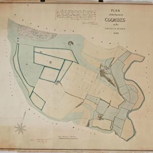
Horsham tithe map, c. 1844 (Part 4)
")
![]()
Wall Art and Photo Gifts from West Sussex County Council
Horsham tithe map, c. 1844 (Part 4)
No date, but Award 1844. Surveyor unknown. 26.6 in. to 1 m. Part I, 52 × 69; Part II, 78 × 106; Part III, 62 × 95; Part IV, 90 × 39; Part V, 66 × 69
Tithe Award Map Collection
West Sussex Record Office Ref No: TD/W68
West Sussex County Council Record Office contains a fascinating history of the county of West Sussex, England
Media ID 10716467
© West Sussex County Council - All Rights Reserved
1840s 19th Century Historical Mapping South Of England
FEATURES IN THESE COLLECTIONS
> Europe
> United Kingdom
> England
> Maps
> Europe
> United Kingdom
> England
> Sussex
> Horsham
> Europe
> United Kingdom
> England
> West Sussex
> Horsham
> Maps and Charts
> Early Maps
> West Sussex County Council
> West Sussex Record Office
> Tithe Award Maps, 1808-1859
EDITORS COMMENTS
This print showcases a piece of history frozen in time - the Horsham tithe map from around 1844. With no known surveyor, this remarkable artifact measures an impressive 26.6 inches to 1 meter, providing intricate details of the land it represents. Divided into five parts, this particular image is Part IV and spans an area of 90 by 39 units. As part of the Tithe Award Map Collection held at West Sussex Record Office, this invaluable document offers a glimpse into the past and sheds light on land ownership and usage during the mid-19th century in southern England. The meticulous craftsmanship evident in its creation highlights its significance as a historical mapping resource. Preserved for generations to come, this print serves as a testament to West Sussex County Council's commitment to preserving our rich heritage. It stands as a reminder of how much our landscape has evolved over time while also honoring those who have walked these lands before us
MADE IN AUSTRALIA
Safe Shipping with 30 Day Money Back Guarantee
FREE PERSONALISATION*
We are proud to offer a range of customisation features including Personalised Captions, Color Filters and Picture Zoom Tools
SECURE PAYMENTS
We happily accept a wide range of payment options so you can pay for the things you need in the way that is most convenient for you
* Options may vary by product and licensing agreement. Zoomed Pictures can be adjusted in the Cart.