Canvas Print > Africa > Zambia > Maps
Canvas Print : Zambia. An early map of Rhodesia and Nyasaland with antiques


![]()
Canvas Prints from Discover Images by AWL
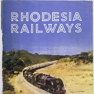
Zambia. An early map of Rhodesia and Nyasaland with antiques
Discover Images by AWL is a world-leading brand of premium quality travel images
Media ID 1646079
© John Warburton-Lee
Antique Antiques Binoculars Chiawa Camp Empire Exploration Lower Zambesi National Park Lower Zambezi National Park Nyasaland Rhodesia Victorian Zambia British Empire Looking Glass Magnifying Glass
20"x16" (51x41cm) Canvas Print
Step back in time with our stunning Canvas Print of "Zambia. An early map of Rhodesia and Nyasaland with antiques" by JWL from Discover Images by AWL. This captivating piece showcases an intriguing historical map of Zambia and its neighboring regions, Rhodesia and Nyasaland, as they once appeared. The vintage charm is enhanced by the inclusion of antique elements, transporting you to a bygone era. Our premium Canvas Prints are meticulously crafted with high-quality materials, ensuring lasting beauty and vibrant colors. Add this unique and thought-provoking piece to your home or office decor and start a conversation about the rich history of Zambia and its fascinating past.
Delivered stretched and ready to hang our premium quality canvas prints are made from a polyester/cotton blend canvas and stretched over a 1.25" (32mm) kiln dried knot free wood stretcher bar. Packaged in a plastic bag and secured to a cardboard insert for safe transit.
Canvas Prints add colour, depth and texture to any space. Professionally Stretched Canvas over a hidden Wooden Box Frame and Ready to Hang
Estimated Product Size is 50.8cm x 40.6cm (20" x 16")
These are individually made so all sizes are approximate
Artwork printed orientated as per the preview above, with landscape (horizontal) orientation to match the source image.
FEATURES IN THESE COLLECTIONS
> Africa
> Related Images
> Africa
> Zambia
> Related Images
> Africa
> Zimbabwe
> Rhodesia
> Maps and Charts
> British Empire Maps
> Maps and Charts
> Early Maps
> Maps and Charts
> Related Images
EDITORS COMMENTS
This print takes us back in time to the historic era of Victorian exploration in Africa. The image showcases an early map of Rhodesia and Nyasaland, now known as Zambia, adorned with a collection of intriguing antiques. As we gaze upon this snapshot from history, we are transported to a bygone age filled with wonder and curiosity. The map itself is a testament to the British Empire's influence on the African continent during that period. It represents not only geographical boundaries but also the spirit of adventure and discovery that characterized this era. With its intricate details and faded colors, it invites us to delve into the past and imagine what life was like for those intrepid explorers who ventured into uncharted territories. Intriguingly, placed alongside the map are various antiques that further enhance our sense of nostalgia. A magnifying glass beckons us to examine every minute detail while binoculars hint at distant horizons waiting to be explored. These artifacts serve as tangible reminders of a time when Africa held untold mysteries and boundless possibilities. As we admire this remarkable composition captured by JWL, our imagination is ignited with thoughts of expeditions through vast wildernesses such as Lower Zambezi National Park or Chiawa Camp. This photograph encapsulates not just a moment frozen in time but also an entire chapter in African history - one defined by exploration, adventure, and the enduring allure of antique treasures from days gone by.
MADE IN AUSTRALIA
Safe Shipping with 30 Day Money Back Guarantee
FREE PERSONALISATION*
We are proud to offer a range of customisation features including Personalised Captions, Color Filters and Picture Zoom Tools
SECURE PAYMENTS
We happily accept a wide range of payment options so you can pay for the things you need in the way that is most convenient for you
* Options may vary by product and licensing agreement. Zoomed Pictures can be adjusted in the Cart.