Fraud Blocker Skip to main content

Home > Maps and Charts > Related Images

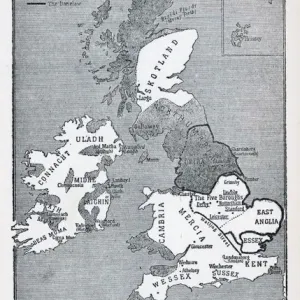
Map of Anglo-Saxon Kingdoms and the Danelaw, 9th Century

Map of Anglo-Saxon Kingdoms and the Danelaw, 9th Century
Sold 24
In Stock
We accept all major credit cards

Fine Art Storehouse Photo Prints and Wall Art

Map of Anglo-Saxon Kingdoms and the Danelaw, 9th Century

Vintage engraving of a Map of Anglo-Saxon Kingdoms and the Danelaw, 9th Century. Unleash your creativity and transform your space into a visual masterpiece. © This content is subject to copyright

duncan1890

Media ID 14549455

Great Britain Mercia Wessex

FEATURES IN THESE COLLECTIONS

> Fine Art Storehouse > Map > Historical Maps

> Fine Art Storehouse > Map

> Maps and Charts > Related Images

SECURE PAYMENTS
We happily accept a wide range of payment options so you can pay for the things you need in the way that is most convenient for you

MADE IN AUSTRALIA
Safe Shipping with 30 Day Money Back Guarantee

FREE PERSONALISATION
We are proud to offer a range of customisation including Cropping, Captions, and Filters. Zoom Cropping can be adjusted in the Basket.


EDITORS COMMENTS

This vintage engraving transports us back to the 9th century, offering a glimpse into the intricate tapestry of power and influence that defined Great Britain during the Anglo-Saxon era. The print showcases a meticulously detailed map, showcasing the various Anglo-Saxon kingdoms and their territories, as well as the enigmatic Danelaw. As our eyes wander across this historical masterpiece, we are drawn to the distinct boundaries that demarcate each kingdom - from Mercia in the heartland to Wessex in the south. Each region is intricately labeled, allowing us to immerse ourselves in an ancient world where rivalries and alliances shaped destinies. The inclusion of Danelaw adds another layer of intrigue to this artwork. This area represents lands under Viking control or influence during this period, highlighting both conflict and cultural exchange between these two formidable forces. Duncan1890's expert craftsmanship breathes life into this print, capturing every minute detail with precision and finesse. The delicate lines etched on paper evoke a sense of nostalgia for bygone times when maps were hand-drawn works of art rather than digital renderings. Whether you are an avid history enthusiast or simply appreciate fine artistry, this exquisite print serves as a window into a pivotal moment in British history. It invites contemplation about how these ancient kingdoms laid foundations for modern-day England while reminding us of our shared heritage rooted deep within these storied landscapes.


Framed Prints

Discover the rich history of Anglo-Saxon England with our stunning Framed Print of the "Map of Anglo-Saxon Kingdoms and the Danelaw, 9th Century" by duncan1890 from our Media Storehouse collection. This vintage engraving transports you back in time, showcasing the intricate details of the Anglo-Saxon kingdoms and the areas influenced by the Danes, known as the Danelaw. Add an air of historical depth to your home or office with this captivating piece of art. The high-quality print is expertly framed, ensuring a timeless display that will surely be the centerpiece of any room. Immerse yourself in history with Media Storehouse's Framed Print of the Anglo-Saxon Map.


Photo Prints

Discover the rich history of the Anglo-Saxon kingdoms and the Danelaw with our exquisite vintage engraving print from the Media Storehouse Fine Art collection. This captivating map, created by the talented artist duncan1890, transports you back to the 9th century, providing a fascinating glimpse into the political landscape of the time. The intricate details of the engraving showcase the various Anglo-Saxon kingdoms and the areas under Viking rule, making it a must-have for history enthusiasts, art collectors, or anyone with an appreciation for vintage cartography. Bring this piece of history into your home or office and add a touch of timeless charm to your decor.


Poster Prints

Discover the rich history of Anglo-Saxon England with our stunning vintage engraving of the Map of Anglo-Saxon Kingdoms and the Danelaw, 9th Century, by duncan1890 from our Media Storehouse collection. This intricately detailed poster print takes you back in time, showcasing the political landscape of the Anglo-Saxon kingdoms and the areas influenced by the Danes, known as the Danelaw. A must-have for history enthusiasts, educators, and anyone with an appreciation for vintage maps. Bring history to life in your home or office with this beautiful, high-quality poster print.


Jigsaw Puzzles

Discover the rich history of Anglo-Saxon England with our captivating jigsaw puzzle from Media Storehouse. This intricately detailed puzzle features a vintage engraving of a Map of Anglo-Saxon Kingdoms and the Danelaw from the 9th Century, created by the talented artist duncan1890 from Fine Art Storehouse. Journey back in time as you piece together this historical masterpiece, learning about the various Anglo-Saxon kingdoms and the areas influenced by the Danes. A perfect activity for history enthusiasts, puzzle lovers, or anyone seeking a challenging and educational pastime. Immerse yourself in the fascinating world of the Anglo-Saxon era, one puzzle piece at a time.

diamond
Made With High Grade Materials
thumb_up
Professional Quality Finish
package_2
Carefully Packed To Aid Safe Arrival

You May Also Like


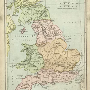
Antique map of Britain under the Anglo SaxonsAntique map of Britain under the Anglo Saxons
Add to Basket
England in the Ninth CenturyEngland in the Ninth Century
Add to Basket
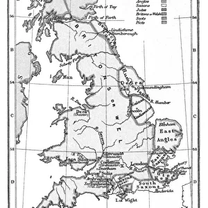
Map of England Showing the Anglo-Saxon Kingdoms and Danish DistrictsMap of England Showing the Anglo-Saxon Kingdoms and Danish Districts
Add to Basket
Antique map of Britain under the Ancient RomansAntique map of Britain under the Ancient Romans
Add to Basket
Old map of England in 550Old map of England in 550
Add to Basket
Old map of England after treaty of Chippenham in 878Old map of England after treaty of Chippenham in 878
Add to Basket
England and wales map 1895England and wales map 1895
Add to Basket
Oliver CromwellOliver Cromwell
Add to Basket
Map of Britain in 597 ADMap of Britain in 597 AD
Add to Basket
Viking Britain MapViking Britain Map
Add to Basket
Praying Hands by Albrecht DurerPraying Hands by Albrecht Durer
Add to Basket
Map of England in 1066Map of England in 1066
Add to Basket

Gallery Wall Inspiration

Map Of New Holland
Antique map of Britain under the Anglo Saxons
Antique map of Britain under the Ancient Romans
Carte du Tendre: imaginary map by a character in the novel Cl├®lie
Map of Exeter in Devon, England Victorian Engraving, 1840
Map of Anglo-Saxon Kingdoms and the Danelaw, 9th Century
England in the Ninth Century
Map of Devon 1883
Newfoundland map 1884
Map of Middle East - illustration
Antique map of the Roman Empire
Old engraved map of Battle of Naseby (14. 06. 1645)
Map of Cyprus, published in 1880
Apostle Pauls Missionary Journeys, lithograph, published in 1886
Battle Of Waterloo
Map of Ireland 1897
Cornwall map 1884
Sicily map 1895
Antique map of Tasmania
Old map of Australia 1899
Ethnological map of the Austro-Hungarian Empire, lithograph, published in 1897
Map of Whitby
Antique map, Scotland, Isle of Skye, South and North Uist
Earth map according to Herodotus
Antique map of Hadrians wall
Antique map of Ireland
Old Caucasus map

Discover Our Collections


MapMap
View Collection
Maps and Charts Related ImagesMaps and Charts Related Images
View Collection
Historical MapsHistorical Maps
View Collection


© Copyright Media Storehouse, All Rights Reserved 2003 - 2024
Facebook     Pinterest     Card Payments     Reviews IO