Framed Print > Maps and Charts > Related Images
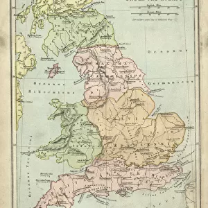
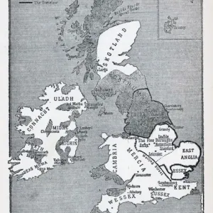
Framed Print : Map of Anglo-Saxon Kingdoms and the Danelaw, 9th Century


![]()
Framed Photos from Fine Art Storehouse
Map of Anglo-Saxon Kingdoms and the Danelaw, 9th Century
Vintage engraving of a Map of Anglo-Saxon Kingdoms and the Danelaw, 9th Century
Unleash your creativity and transform your space into a visual masterpiece!
duncan1890
Media ID 14549455
© This content is subject to copyright
A2 Premium Frame with A3 Poster
Discover the rich history of Anglo-Saxon England with our stunning Framed Print of the "Map of Anglo-Saxon Kingdoms and the Danelaw, 9th Century" by duncan1890 from our Media Storehouse collection. This vintage engraving transports you back in time, showcasing the intricate details of the Anglo-Saxon kingdoms and the areas influenced by the Danes, known as the Danelaw. Add an air of historical depth to your home or office with this captivating piece of art. The high-quality print is expertly framed, ensuring a timeless display that will surely be the centerpiece of any room. Immerse yourself in history with Media Storehouse's Framed Print of the Anglo-Saxon Map.
Premium Paradise Wooden Range A2 Premium Poster Frame (62x45cm) with A3 Poster (42x30cm) and mounted behind a white matt board to make your photo really stand out. FSC Certified and Rainforest Alliance Certified for environmental, social, and economic sustainably. High transparency tempered glass window with a smooth finished frame. Great for filling empty walls, decorating blank spaces, or creating eye-catching gallery walls. Frames arrive ready to hang. Sent with secure, protective packaging. Smooth wooden veneer mimics the real wood look and feel with ultra-durable scratch resistance tempered glass.
Contemporary Framed and Mounted Prints - Professionally Made and Ready to Hang
Estimated Image Size (if not cropped) is 40.4cm x 40.4cm (15.9" x 15.9")
Estimated Product Size is 44.6cm x 62cm (17.6" x 24.4")
These are individually made so all sizes are approximate
Artwork printed orientated as per the preview above, with landscape (horizontal) or portrait (vertical) orientation to match the source image.
FEATURES IN THESE COLLECTIONS
> Fine Art Storehouse
> Map
> Historical Maps
> Maps and Charts
> Related Images
EDITORS COMMENTS
This vintage engraving transports us back to the 9th century, offering a glimpse into the intricate tapestry of power and influence that defined Great Britain during the Anglo-Saxon era. The print showcases a meticulously detailed map, showcasing the various Anglo-Saxon kingdoms and their territories, as well as the enigmatic Danelaw. As our eyes wander across this historical masterpiece, we are drawn to the distinct boundaries that demarcate each kingdom - from Mercia in the heartland to Wessex in the south. Each region is intricately labeled, allowing us to immerse ourselves in an ancient world where rivalries and alliances shaped destinies. The inclusion of Danelaw adds another layer of intrigue to this artwork. This area represents lands under Viking control or influence during this period, highlighting both conflict and cultural exchange between these two formidable forces. Duncan1890's expert craftsmanship breathes life into this print, capturing every minute detail with precision and finesse. The delicate lines etched on paper evoke a sense of nostalgia for bygone times when maps were hand-drawn works of art rather than digital renderings. Whether you are an avid history enthusiast or simply appreciate fine artistry, this exquisite print serves as a window into a pivotal moment in British history. It invites contemplation about how these ancient kingdoms laid foundations for modern-day England while reminding us of our shared heritage rooted deep within these storied landscapes.
MADE IN AUSTRALIA
Safe Shipping with 30 Day Money Back Guarantee
FREE PERSONALISATION*
We are proud to offer a range of customisation features including Personalised Captions, Color Filters and Picture Zoom Tools
SECURE PAYMENTS
We happily accept a wide range of payment options so you can pay for the things you need in the way that is most convenient for you
* Options may vary by product and licensing agreement. Zoomed Pictures can be adjusted in the Cart.