Canvas Print > Europe > France > Canton > Landes
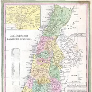
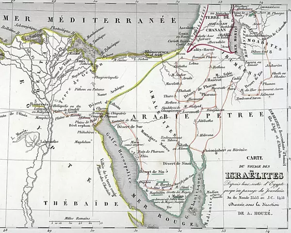
Canvas Print : Map showing the route of the Israelites from Egypt to the passage of the Jordan ers 1451 BC (Exodus) (Map showing the exodus route from Egypt to Canaan land) Engraving from Houze 1851 Universal Atlas" Private collection
 (Map showing the exodus route from Egypt to Canaan land) Engraving from Houze 1851 Universal Atlas' Private collection")
 (Map showing the exodus route from Egypt to Canaan land) Engraving from Houze 1851 Universal Atlas' Private collection")

![]()
Canvas Prints from Fine Art Finder
Map showing the route of the Israelites from Egypt to the passage of the Jordan ers 1451 BC (Exodus) (Map showing the exodus route from Egypt to Canaan land) Engraving from Houze 1851 Universal Atlas" Private collection
ELD4921971 Map showing the route of the Israelites from Egypt to the passage of the Jordan ers 1451 BC (Exodus) (Map showing the exodus route from Egypt to Canaan land) Engraving from Houze 1851 Universal Atlas" Private collection; (add.info.: Map showing the route of the Israelites from Egypt to the passage of the Jordan ers 1451 BC (Exodus) (Map showing the exodus route from Egypt to Canaan land) Engraving from Houze 1851 Universal Atlas" Private collection); Photo © The Holbarn Archive
Media ID 38098260
© © The Holbarn Archive / Bridgeman Images
Exodus Israel Israeli Judaic Egyptians Geographical Map Isadora Jewish Religion Jews
20"x16" (51x41cm) Canvas Print
Explore the ancient journey of the Israelites with this stunning canvas print from Media Storehouse. Featuring a historical map showing their route from Egypt to Canaan, this piece is sure to add a touch of intrigue and sophistication to any space.
Delivered stretched and ready to hang our premium quality canvas prints are made from a polyester/cotton blend canvas and stretched over a 1.25" (32mm) kiln dried knot free wood stretcher bar. Packaged in a plastic bag and secured to a cardboard insert for safe transit.
Canvas Prints add colour, depth and texture to any space. Professionally Stretched Canvas over a hidden Wooden Box Frame and Ready to Hang
Estimated Product Size is 50.8cm x 40.6cm (20" x 16")
These are individually made so all sizes are approximate
Artwork printed orientated as per the preview above, with landscape (horizontal) orientation to match the source image.
FEATURES IN THESE COLLECTIONS
> Africa
> Egypt
> Related Images
> Africa
> Related Images
> Asia
> Israel
> Related Images
> Europe
> France
> Canton
> Landes
> Maps and Charts
> Early Maps
> Fine Art Finder
> Artists
> Artist Unknown
EDITORS COMMENTS
This engraving from the 1851 Universal Atlas depicts the historic journey of the Israelites from Egypt to Canaan, as described in the biblical account of Exodus. The detailed map showcases the route taken by Moses and his people as they fled slavery in Egypt and embarked on their epic pilgrimage towards the promised land.
The intricate lines and markings on this print offer a glimpse into the geographical challenges faced by the Israelites during their exodus, highlighting key locations such as Mount Sinai and the crossing of the Red Sea. The visual representation of this ancient migration serves as a powerful reminder of faith, perseverance, and divine intervention.
As we study this map showing the passage of time from 1451 BC, we are transported back to a pivotal moment in history when a nation was born out of hardship and triumph. The significance of this journey resonates with believers around the world who draw inspiration from the courage and resilience displayed by Moses and his followers.
This rare print is not just a historical artifact but also a testament to human endurance and unwavering belief in a higher power. It stands as a symbol of hope for all those navigating their own paths through life's trials and tribulations.
MADE IN AUSTRALIA
Safe Shipping with 30 Day Money Back Guarantee
FREE PERSONALISATION*
We are proud to offer a range of customisation features including Personalised Captions, Color Filters and Picture Zoom Tools
SECURE PAYMENTS
We happily accept a wide range of payment options so you can pay for the things you need in the way that is most convenient for you
* Options may vary by product and licensing agreement. Zoomed Pictures can be adjusted in the Cart.