Canvas Print > Fine Art Finder > Maps (celestial & Terrestrial)
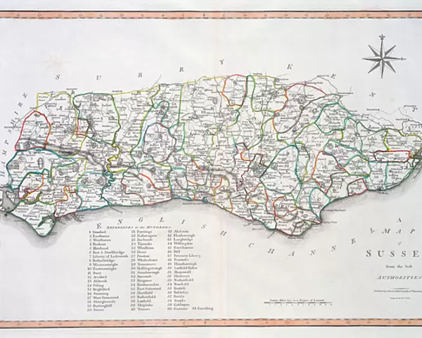
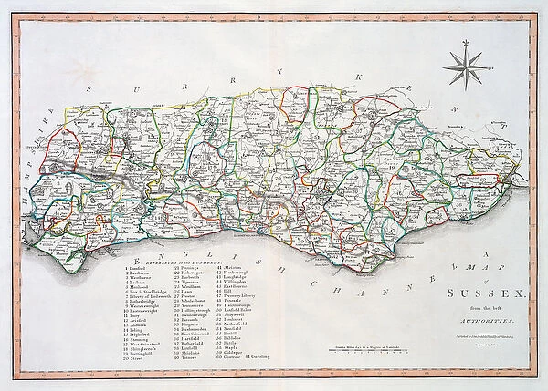
Canvas Print : Map of Sussex, 26th March 1805 (hand coloured engraving)
")
")

![]()
Canvas Prints from Fine Art Finder
Map of Sussex, 26th March 1805 (hand coloured engraving)
XCF275036 Map of Sussex, 26th March 1805 (hand coloured engraving) by Cary, John (c.1754-1835) (after); Private Collection; English, out of copyright
Media ID 12790627
© www.bridgemanimages.com
Borders County English Channel Geographical Mapping Regency
20"x16" (51x41cm) Canvas Print
Add a touch of historical charm to your home decor with the Media Storehouse Canvas Prints featuring the exquisite Map of Sussex, 26th March 1805 (hand coloured engraving). This beautiful antique map, originally created by John Cary in 1805, showcases the intricate details of Sussex county during that era. Hand-coloured and meticulously engraved, this fine art print from Bridgeman Images transports you back in time. Hang it in your living room, office or study to add a unique and thought-provoking piece to your collection. Out of copyright and available now at Media Storehouse.
Delivered stretched and ready to hang our premium quality canvas prints are made from a polyester/cotton blend canvas and stretched over a 1.25" (32mm) kiln dried knot free wood stretcher bar. Packaged in a plastic bag and secured to a cardboard insert for safe transit.
Canvas Prints add colour, depth and texture to any space. Professionally Stretched Canvas over a hidden Wooden Box Frame and Ready to Hang
Estimated Product Size is 50.8cm x 40.6cm (20" x 16")
These are individually made so all sizes are approximate
Artwork printed orientated as per the preview above, with landscape (horizontal) orientation to match the source image.
FEATURES IN THESE COLLECTIONS
> Fine Art Finder
> Artists
> John (after) Cary
> Fine Art Finder
> Maps (celestial & Terrestrial)
EDITORS COMMENTS
This print showcases a meticulously hand-coloured engraving of the "Map of Sussex, 26th March 1805" by John Cary. A true masterpiece from the Regency era, this map offers an intriguing glimpse into the geographical landscape of historic Sussex. With its intricate details and precise cartography, it transports us back to a time when borders were defined differently and exploration was at its peak. The artist's skillful rendering brings forth every contour and feature of this English county with remarkable accuracy. From the rolling hills to the meandering rivers, each element is thoughtfully depicted, offering a comprehensive understanding of Sussex's geography. The map even extends beyond land boundaries, capturing a portion of the English Channel that adds another layer to its significance. As we delve into this visual treasure trove, we are reminded not only of our fascination with maps but also their vital role in shaping history. This particular piece serves as both an educational tool and a work of art; it invites us to explore and appreciate the intricacies that lie within our own surroundings. Now preserved in a private collection, this hand-coloured engraving stands as a testament to Cary's talent as well as his dedication to accurately documenting England's counties. Its timeless beauty continues to captivate viewers today, providing an enchanting window into Sussex's past while igniting curiosity about what lies beyond its carefully drawn borders.
MADE IN AUSTRALIA
Safe Shipping with 30 Day Money Back Guarantee
FREE PERSONALISATION*
We are proud to offer a range of customisation features including Personalised Captions, Color Filters and Picture Zoom Tools
SECURE PAYMENTS
We happily accept a wide range of payment options so you can pay for the things you need in the way that is most convenient for you
* Options may vary by product and licensing agreement. Zoomed Pictures can be adjusted in the Cart.