Canvas Print > Fine Art Storehouse > Map
Canvas Print : Map of North America 1867


![]()
Canvas Prints from Fine Art Storehouse
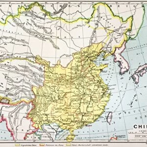
Map of North America 1867
Mitchells Modern Atlas - Published by E.H. Buttler & Co - Philadelphia 1867
Unleash your creativity and transform your space into a visual masterpiece!
THEPALMER
Media ID 13668945
© Roberto A Sanchez
Atlantic Ocean Background Backgrounds Direction Grunge Grunge Image Technique North America Sepia Toned Obsolete
20"x16" (51x41cm) Canvas Print
Step back in time with our exquisite Canvas Print of the Mitchells Modern Atlas Map of North America, a captivating piece from 1867 by THEPALMER from the Fine Art Storehouse at Media Storehouse. This vintage map, published by E.H. Buttler & Co in Philadelphia, showcases intricate detail and historical accuracy. Each canvas print is meticulously crafted using premium materials, resulting in stunning visual clarity and vibrant colors. Transform your space into a captivating time capsule with this unique and intriguing addition to your decor.
Delivered stretched and ready to hang our premium quality canvas prints are made from a polyester/cotton blend canvas and stretched over a 1.25" (32mm) kiln dried knot free wood stretcher bar. Packaged in a plastic bag and secured to a cardboard insert for safe transit.
Canvas Prints add colour, depth and texture to any space. Professionally Stretched Canvas over a hidden Wooden Box Frame and Ready to Hang
Estimated Product Size is 40.6cm x 50.8cm (16" x 20")
These are individually made so all sizes are approximate
Artwork printed orientated as per the preview above, with portrait (vertical) orientation to match the source image.
FEATURES IN THESE COLLECTIONS
> Fine Art Storehouse
> The Magical World of Illustration
> Palmer Illustrated Collection
> Fine Art Storehouse
> Map
> Historical Maps
> Fine Art Storehouse
> Map
> USA Maps
EDITORS COMMENTS
This print showcases a piece of history frozen in time - the "Map of North America 1867". Published by E. H. Buttler & Co in Philadelphia, this exquisite engraving from Mitchell's Modern Atlas takes us back to an era when cartography was an art form. The sepia-toned image exudes a sense of nostalgia and transports us to a world where physical geography was meticulously documented. The intricate details etched into the map reveal the vastness and diversity of North America during that period. From the sprawling landscapes of the United States to the majestic Atlantic Ocean, every contour is delicately captured through this grunge image technique. The vertical composition adds depth and perspective, allowing viewers to immerse themselves in this historical journey. As we gaze upon this aged background illustration, it becomes evident how much our understanding of direction and boundaries has evolved over time. This obsolete representation reminds us that maps are not just tools for navigation but also windows into our past. "The Map of North America 1867" by THEPALMER serves as a reminder that even though technology may have transformed how we perceive our world today, there is still immense beauty in these old-fashioned engravings. It invites us to appreciate both the artistry behind cartography and the rich tapestry of history woven within each line on this mesmerizing print.
MADE IN AUSTRALIA
Safe Shipping with 30 Day Money Back Guarantee
FREE PERSONALISATION*
We are proud to offer a range of customisation features including Personalised Captions, Color Filters and Picture Zoom Tools
SECURE PAYMENTS
We happily accept a wide range of payment options so you can pay for the things you need in the way that is most convenient for you
* Options may vary by product and licensing agreement. Zoomed Pictures can be adjusted in the Cart.