Canvas Print > Fine Art Storehouse > Map
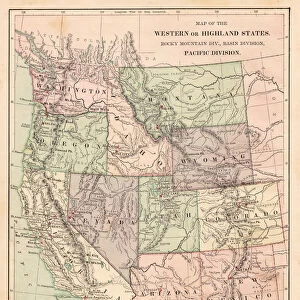
Canvas Print : Pacific USA states map 1869


![]()
Canvas Prints from Fine Art Storehouse
Pacific USA states map 1869
Cornells Grammars-School Geography - S.S. Cornell - New York D. Appleton and Company 1869
Unleash your creativity and transform your space into a visual masterpiece!
THEPALMER
Media ID 13668861
© Roberto A Sanchez
California New Mexico Oregon Oregon Us State Pacific Ocean Utah Washington State Obsolete
20"x16" (51x41cm) Canvas Print
Step back in time with our exquisite Pacific USA States Map Canvas Print from Media Storehouse's Fine Art Storehouse collection. This stunning piece of historical art is based on the 1869 Pacific USA States Map by THEPALMER, as originally published in Cornell's Grammars-School Geography by S.S. Cornell - New York D. Appleton and Company. Each canvas print is meticulously crafted with attention to detail, bringing the intricacies of this vintage map to life. Add a touch of history and character to your home or office decor with this unique and captivating canvas print.
Delivered stretched and ready to hang our premium quality canvas prints are made from a polyester/cotton blend canvas and stretched over a 1.25" (32mm) kiln dried knot free wood stretcher bar. Packaged in a plastic bag and secured to a cardboard insert for safe transit.
Canvas Prints add colour, depth and texture to any space. Professionally Stretched Canvas over a hidden Wooden Box Frame and Ready to Hang
Estimated Product Size is 40.6cm x 50.8cm (16" x 20")
These are individually made so all sizes are approximate
Artwork printed orientated as per the preview above, with portrait (vertical) orientation to match the source image.
FEATURES IN THESE COLLECTIONS
> Fine Art Storehouse
> The Magical World of Illustration
> Palmer Illustrated Collection
> Fine Art Storehouse
> Map
> Historical Maps
> Fine Art Storehouse
> Map
> USA Maps
EDITORS COMMENTS
This print showcases a remarkable piece of cartographic history, the "Pacific USA states map 1869". Taken from the renowned Cornells Grammars-School Geography by S. S. Cornell and published by D. Appleton and Company in New York back in 1869, this engraving offers us a glimpse into the past world of physical geography. The intricate details etched onto this obsolete map are truly awe-inspiring. From the sprawling coastlines of California, Oregon, Washington State, and even stretching across to New Mexico, it presents an accurate representation of these Pacific USA states as they were over a century ago. The vast expanse of the Pacific Ocean dominates its borders, reminding us of its significance in shaping both land and culture. As we delve deeper into this vertical illustration expertly captured by THEPALMER for Fine Art Storehouse's collection, we can't help but appreciate the craftsmanship behind such engravings. Each line meticulously engraved on this old map tells a story - one that connects us to our historical roots while showcasing how far we have come. Whether you're an avid collector or simply fascinated by maps and their ability to transport us through time and space, this print is sure to captivate your imagination. Let it serve as a reminder that beneath every inch lies layers upon layers of forgotten tales waiting to be discovered anew.
MADE IN AUSTRALIA
Safe Shipping with 30 Day Money Back Guarantee
FREE PERSONALISATION*
We are proud to offer a range of customisation features including Personalised Captions, Color Filters and Picture Zoom Tools
SECURE PAYMENTS
We happily accept a wide range of payment options so you can pay for the things you need in the way that is most convenient for you
* Options may vary by product and licensing agreement. Zoomed Pictures can be adjusted in the Cart.