Canvas Print > Fine Art Storehouse > Map
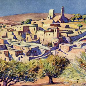
Canvas Print : South America relief map 1875


![]()
Canvas Prints from Fine Art Storehouse
South America relief map 1875
The Independent Course Comprehensive Geography by James Monteith, A.S. Barnes & Co, New York & Chicago 1875
Unleash your creativity and transform your space into a visual masterpiece!
THEPALMER
Media ID 13612213
© This content is subject to copyright
Globe Navigational Equipment Paper Relief Relief Carving Relief Map South America
20"x16" (51x41cm) Canvas Print
Step back in time with our exquisite South America Relief Map 1875 canvas print from The Palmer Collection at Media Storehouse. This fine art piece, inspired by James Monteith's The Independent Course in Comprehensive Geography published in 1875, showcases an intricately detailed map of South America during a pivotal era in cartography. The vintage aesthetic of this relief map is beautifully rendered on a high-quality canvas, creating a captivating conversation starter and a unique addition to any home or office decor. Travel back in time and explore the historical geography of South America with this stunning work of art.
Delivered stretched and ready to hang our premium quality canvas prints are made from a polyester/cotton blend canvas and stretched over a 1.25" (32mm) kiln dried knot free wood stretcher bar. Packaged in a plastic bag and secured to a cardboard insert for safe transit.
Canvas Prints add colour, depth and texture to any space. Professionally Stretched Canvas over a hidden Wooden Box Frame and Ready to Hang
Estimated Product Size is 40.6cm x 50.8cm (16" x 20")
These are individually made so all sizes are approximate
Artwork printed orientated as per the preview above, with portrait (vertical) orientation to match the source image.
FEATURES IN THESE COLLECTIONS
> Fine Art Storehouse
> The Magical World of Illustration
> Palmer Illustrated Collection
> Fine Art Storehouse
> Map
> Historical Maps
> Fine Art Storehouse
> Map
> USA Maps
EDITORS COMMENTS
This print takes us back in time to the year 1875, when James Monteith's "South America relief map" was first published in his renowned book, "The Independent Course Comprehensive Geography". The map, beautifully engraved on paper, showcases the intricate details of South America's physical geography. As we gaze upon this antique masterpiece, we are transported to an era where cartography and navigational equipment were essential tools for exploration. The relief carving technique used in this illustration brings depth and texture to the map, allowing us to visualize the mountain ranges, rivers, and coastlines that define South America's diverse landscape. This vertical composition captures our attention with its precision and accuracy. As we delve into this historical artifact from A. S. Barnes & Co. , New York & Chicago, we can't help but appreciate the craftsmanship involved in creating such a detailed representation of a continent. The old-world charm emanating from this image reminds us of how far our understanding of geography has come over the years. "The Independent Course Comprehensive Geography" by James Monteith continues to be a testament to human curiosity and exploration. Through THEPALMER's lens at Fine Art Storehouse, this print preserves not only a piece of history but also serves as a reminder of mankind's endless quest for knowledge about our planet's wondrous landscapes.
MADE IN AUSTRALIA
Safe Shipping with 30 Day Money Back Guarantee
FREE PERSONALISATION*
We are proud to offer a range of customisation features including Personalised Captions, Color Filters and Picture Zoom Tools
SECURE PAYMENTS
We happily accept a wide range of payment options so you can pay for the things you need in the way that is most convenient for you
* Options may vary by product and licensing agreement. Zoomed Pictures can be adjusted in the Cart.