Canvas Print > Asia > Palestine > Maps
Canvas Print : Antique Map of Ancient Palestine


![]()
Canvas Prints from Fine Art Storehouse
Antique Map of Ancient Palestine
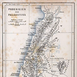
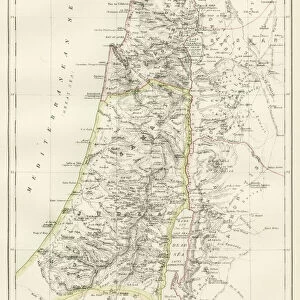
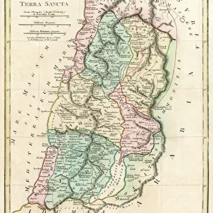
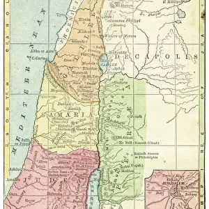
Antique Map from 1862 of Ancient Palestine. Showing Palestine before exile; Palestine and Lower Egypt; Jerusalem; and the Kingdom of David and Solomon. Maps text is written in Latin
Unleash your creativity and transform your space into a visual masterpiece!
duncan1890
Media ID 18062903
© Duncan Walker
20"x16" (51x41cm) Canvas Print
Step back in time with our exquisite Canvas Print of an Antique Map of Ancient Palestine from the Fine Art Storehouse by duncan1890. This captivating piece showcases an intricately detailed map from 1862, depicting Palestine before the exile, including Palestine and Lower Egypt, Jerusalem, and the Kingdom of David and Solomon. The map text is beautifully written in Latin, adding to its historical allure. Bring a touch of the past into your home or office with this stunning and authentic work of art.
Delivered stretched and ready to hang our premium quality canvas prints are made from a polyester/cotton blend canvas and stretched over a 1.25" (32mm) kiln dried knot free wood stretcher bar. Packaged in a plastic bag and secured to a cardboard insert for safe transit.
Canvas Prints add colour, depth and texture to any space. Professionally Stretched Canvas over a hidden Wooden Box Frame and Ready to Hang
Estimated Product Size is 50.8cm x 40.6cm (20" x 16")
These are individually made so all sizes are approximate
Artwork printed orientated as per the preview above, with landscape (horizontal) orientation to match the source image.
FEATURES IN THESE COLLECTIONS
> Africa
> Egypt
> Related Images
> Asia
> Palestine
> Jerusalem
> Asia
> Palestine
> Related Images
> Historic
> Ancient civilizations
> Ancient Egypt
> Historic
> Ancient civilizations
> Maps and Charts
> Early Maps
> Maps and Charts
> Related Images
> Fine Art Storehouse
> Map
> Historical Maps
EDITORS COMMENTS
This print takes us back in time to the ancient land of Palestine, offering a glimpse into its rich history and civilization. Dating all the way back to 1862, this antique map showcases Palestine before exile, presenting an invaluable resource for historians and enthusiasts alike. The intricate details on this map are truly remarkable. From the borders of Palestine and Lower Egypt to the majestic city of Jerusalem, every line tells a story of ancient civilizations that once thrived in these lands. The Kingdom of David and Solomon is prominently featured, reminding us of their legendary reigns and contributions. What makes this piece even more intriguing is that it is written entirely in Latin. This adds an air of mystery as we delve deeper into deciphering the text and uncovering hidden meanings within its pages. It serves as a testament to the scholarly pursuits during that era when Latin was widely used as a language for academia. As we gaze upon this mesmerizing artwork, we are transported through time, immersing ourselves in the wonders of ancient cartography. It invites us to explore not only geographical boundaries but also cultural exchanges between neighboring regions. Duncan1890's masterful capture ensures that this antique map remains preserved for generations to come – a window into our past where history comes alive with each glance.
MADE IN AUSTRALIA
Safe Shipping with 30 Day Money Back Guarantee
FREE PERSONALISATION*
We are proud to offer a range of customisation features including Personalised Captions, Color Filters and Picture Zoom Tools
SECURE PAYMENTS
We happily accept a wide range of payment options so you can pay for the things you need in the way that is most convenient for you
* Options may vary by product and licensing agreement. Zoomed Pictures can be adjusted in the Cart.