Canvas Print > Arts > Artists > B > Augustus Butler
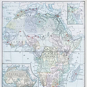
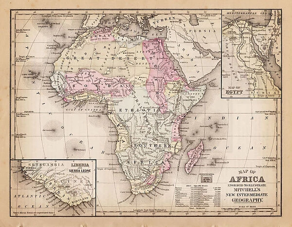
Canvas Print : Map of Africa 1881


![]()
Canvas Prints from Fine Art Storehouse
Map of Africa 1881
A System of Modern Geography designed for the use of schools and academies by Augustus Mitchell - Published by T. H. Butler / Philadelphia 1881
Unleash your creativity and transform your space into a visual masterpiece!
THEPALMER
Media ID 18357215
20"x16" (51x41cm) Canvas Print
Discover the rich history of Africa with our stunning Canvas Print of the Map of Africa 1881 by THEPALMER from the Media Storehouse Fine Art Storehouse collection. This captivating vintage map, published by T. H. Butler in Philadelphia in 1881, is taken from A System of Modern Geography designed for the use of schools and academies by Augustus Mitchell. Bring the intrigue and wonder of the past into your home or office with this beautifully detailed and vibrant Canvas Print, perfect for history enthusiasts, world travelers, or anyone who appreciates the art of cartography.
Delivered stretched and ready to hang our premium quality canvas prints are made from a polyester/cotton blend canvas and stretched over a 1.25" (32mm) kiln dried knot free wood stretcher bar. Packaged in a plastic bag and secured to a cardboard insert for safe transit.
Canvas Prints add colour, depth and texture to any space. Professionally Stretched Canvas over a hidden Wooden Box Frame and Ready to Hang
Estimated Product Size is 50.8cm x 40.6cm (20" x 16")
These are individually made so all sizes are approximate
Artwork printed orientated as per the preview above, with landscape (horizontal) orientation to match the source image.
FEATURES IN THESE COLLECTIONS
> Africa
> Related Images
> Arts
> Artists
> B
> Augustus Butler
> Maps and Charts
> Related Images
> Fine Art Storehouse
> Map
> Historical Maps
EDITORS COMMENTS
In this print titled "Map of Africa 1881" we are transported back in time to the late 19th century, when cartography was a blend of artistry and scientific precision. This particular map, designed by Augustus Mitchell and published by T. H. Butler in Philadelphia in 1881, offers us a glimpse into the world as it was perceived during that era. The intricate details on this vintage map take us on a journey across the vast continent of Africa, revealing its diverse landscapes and rich cultural tapestry. From the mighty Nile River snaking through Egypt to the expansive Sahara Desert stretching across North Africa, every line and contour tells a story waiting to be explored. As we study this historical artifact, we can appreciate both its educational purpose for schools and academies at that time and its artistic value today. The careful craftsmanship evident in each stroke showcases Mitchell's dedication to accuracy while also highlighting his talent as an illustrator. Through THEPALMER's lens capturing this print from Fine Art Storehouse, we are reminded of how maps have long served as windows into our collective understanding of the world. They not only guide us physically but also spark our curiosity about distant lands and cultures beyond our own. This remarkable image invites us to reflect upon Africa's past while contemplating its present-day transformation—a testament to both human progress and nature's enduring beauty.
MADE IN AUSTRALIA
Safe Shipping with 30 Day Money Back Guarantee
FREE PERSONALISATION*
We are proud to offer a range of customisation features including Personalised Captions, Color Filters and Picture Zoom Tools
SECURE PAYMENTS
We happily accept a wide range of payment options so you can pay for the things you need in the way that is most convenient for you
* Options may vary by product and licensing agreement. Zoomed Pictures can be adjusted in the Cart.