Photographic Print > Arts > Artists > B > Augustus Butler
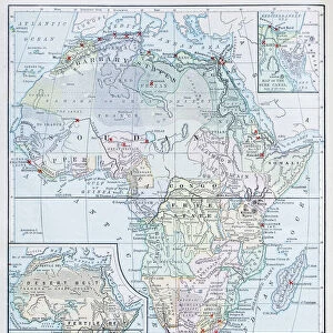
Photographic Print : Map of Africa 1881


![]()
Photo Prints from Fine Art Storehouse
Map of Africa 1881
A System of Modern Geography designed for the use of schools and academies by Augustus Mitchell - Published by T. H. Butler / Philadelphia 1881
Unleash your creativity and transform your space into a visual masterpiece!
THEPALMER
Media ID 18357215
10"x8" (25x20cm) Photo Print
Discover the historical allure of the past with our exquisite print of "Map of Africa 1881" by THEPALMER from our Media Storehouse collection. This fine art print is a captivating piece from the System of Modern Geography designed for schools and academies by Augustus Mitchell, published by T. H. Butler in Philadelphia, 1881. With intricate detail and vibrant colors, this print transports you back in time, offering a unique perspective of the African continent during a pivotal period in its history. Ideal for history enthusiasts, educators, and collectors, this beautiful print makes a stunning addition to any home or office decor.
Ideal for framing, Australian made Photo Prints are produced on high-quality 270 gsm lustre photo paper which has a subtle shimmer adding a touch of elegance, designed to enhance their visual appeal.
Our Photo Prints are in a large range of sizes and are printed on Archival Quality Paper for excellent colour reproduction and longevity. They are ideal for framing (our Framed Prints use these) at a reasonable cost. Alternatives include cheaper Poster Prints and higher quality Fine Art Paper, the choice of which is largely dependant on your budget.
Estimated Product Size is 25.4cm x 20.3cm (10" x 8")
These are individually made so all sizes are approximate
Artwork printed orientated as per the preview above, with landscape (horizontal) or portrait (vertical) orientation to match the source image.
FEATURES IN THESE COLLECTIONS
> Fine Art Storehouse
> Map
> Historical Maps
> Africa
> Related Images
> Arts
> Artists
> B
> Augustus Butler
> Maps and Charts
> Related Images
EDITORS COMMENTS
In this print titled "Map of Africa 1881" we are transported back in time to the late 19th century, when cartography was a blend of artistry and scientific precision. This particular map, designed by Augustus Mitchell and published by T. H. Butler in Philadelphia in 1881, offers us a glimpse into the world as it was perceived during that era. The intricate details on this vintage map take us on a journey across the vast continent of Africa, revealing its diverse landscapes and rich cultural tapestry. From the mighty Nile River snaking through Egypt to the expansive Sahara Desert stretching across North Africa, every line and contour tells a story waiting to be explored. As we study this historical artifact, we can appreciate both its educational purpose for schools and academies at that time and its artistic value today. The careful craftsmanship evident in each stroke showcases Mitchell's dedication to accuracy while also highlighting his talent as an illustrator. Through THEPALMER's lens capturing this print from Fine Art Storehouse, we are reminded of how maps have long served as windows into our collective understanding of the world. They not only guide us physically but also spark our curiosity about distant lands and cultures beyond our own. This remarkable image invites us to reflect upon Africa's past while contemplating its present-day transformation—a testament to both human progress and nature's enduring beauty.
MADE IN AUSTRALIA
Safe Shipping with 30 Day Money Back Guarantee
FREE PERSONALISATION*
We are proud to offer a range of customisation features including Personalised Captions, Color Filters and Picture Zoom Tools
SECURE PAYMENTS
We happily accept a wide range of payment options so you can pay for the things you need in the way that is most convenient for you
* Options may vary by product and licensing agreement. Zoomed Pictures can be adjusted in the Cart.