
Canvas Print > Fine Art Storehouse > Map
Canvas Print : Map of Hannover 1900


![]()
Canvas Prints from Fine Art Storehouse
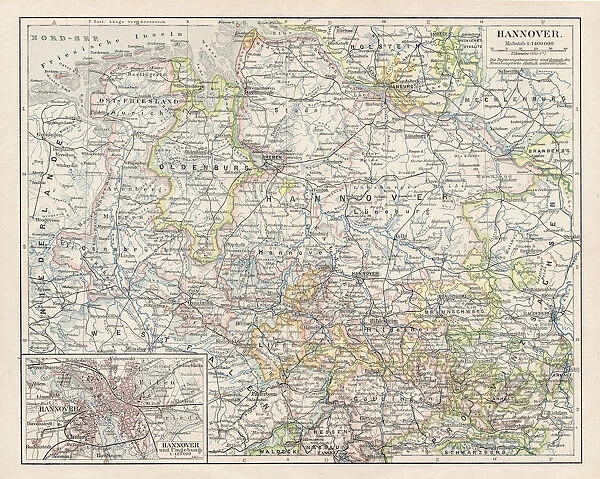
Map of Hannover 1900
Meyers hand-Atlas Leipzig und Wien Verlag des Bibliographischen Instituts 1900
Unleash your creativity and transform your space into a visual masterpiece!
THEPALMER
Media ID 18106913
© 2014 Roberto Adrian Photography
20"x16" (51x41cm) Canvas Print
Step back in time with our exquisite Canvas Print of the Map of Hannover 1900 from THEPALMER's collection at Media Storehouse. This stunning piece, taken from the esteemed Meyers Hand-Atlas published by the Bibliographischen Instituts Leipzig und Wien Verlag in 1900, adds an air of historical intrigue to any space. The intricate details of the map are beautifully rendered on premium canvas, creating a vibrant and textured finish. Transport yourself to a bygone era with this captivating work of art.
Delivered stretched and ready to hang our premium quality canvas prints are made from a polyester/cotton blend canvas and stretched over a 1.25" (32mm) kiln dried knot free wood stretcher bar. Packaged in a plastic bag and secured to a cardboard insert for safe transit.
Canvas Prints add colour, depth and texture to any space. Professionally Stretched Canvas over a hidden Wooden Box Frame and Ready to Hang
Estimated Product Size is 50.8cm x 40.6cm (20" x 16")
These are individually made so all sizes are approximate
Artwork printed orientated as per the preview above, with landscape (horizontal) orientation to match the source image.
FEATURES IN THESE COLLECTIONS
> Fine Art Storehouse
> Map
> Historical Maps
EDITORS COMMENTS
In this print titled "Map of Hannover 1900". THEPALMER takes us on a journey back in time to the turn of the century. The image showcases an exquisite map from Meyers hand-Atlas Leipzig und Wien Verlag des Bibliographischen Instituts, published in 1900. The map itself is a testament to the artistry and craftsmanship that went into cartography during this era. Every intricate detail has been meticulously captured, allowing viewers to immerse themselves in the city's rich history and architectural marvels. From its bustling streets to its grand landmarks, Hannover comes alive through this vintage representation. As we gaze upon this piece, we are transported back to a time when maps were not just navigational tools but works of art that celebrated human exploration and discovery. The delicate lines and vibrant colors evoke a sense of wonderment as we explore every nook and cranny of Hannover's past. THEPALMER's choice to present this historical gem as a print allows us to appreciate it with renewed clarity and appreciation for its cultural significance. It serves as both an educational resource for historians and geography enthusiasts alike, while also offering an aesthetic appeal that can enhance any space. "Map of Hannover 1900" invites us all on an enchanting voyage through time, reminding us of our collective heritage while igniting our curiosity about the world around us.
MADE IN AUSTRALIA
Safe Shipping with 30 Day Money Back Guarantee
FREE PERSONALISATION*
We are proud to offer a range of customisation features including Personalised Captions, Color Filters and Picture Zoom Tools
SECURE PAYMENTS
We happily accept a wide range of payment options so you can pay for the things you need in the way that is most convenient for you
* Options may vary by product and licensing agreement. Zoomed Pictures can be adjusted in the Cart.