
Metal Print > Fine Art Storehouse > Map
Metal Print : Map of Hannover 1900


![]()
Metal Prints from Fine Art Storehouse
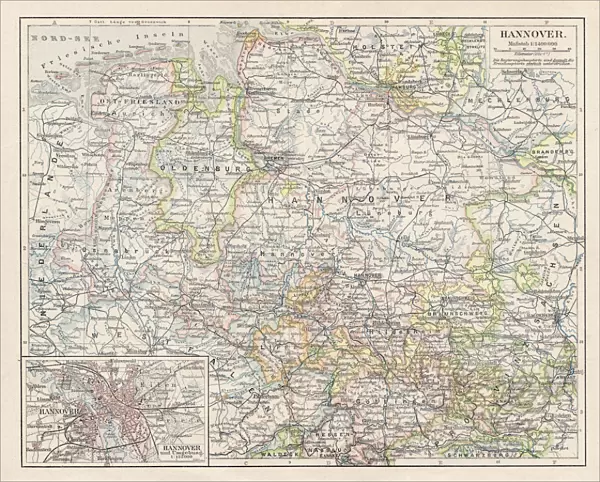
Map of Hannover 1900
Meyers hand-Atlas Leipzig und Wien Verlag des Bibliographischen Instituts 1900
Unleash your creativity and transform your space into a visual masterpiece!
THEPALMER
Media ID 18106913
© 2014 Roberto Adrian Photography
10"x8" (25x20cm) Table Top Metal Print
Discover the rich history of Hannover with our stunning Metal Print of the Map of Hannover 1900 from THEPALMER's collection at Media Storehouse. This exquisite piece is taken from the renowned Meyers Hand-Atlas published by the Bibliographischen Institut in Leipzig and Wien in 1900. The intricate details of the map are brought to life through our high-quality Metal Print process, adding depth and dimension to this historical artwork. Elevate your home or office decor with this unique and captivating piece that tells a story of the past. #MapOfHannover1900 #THEPALMER #HistoricalArt #MetalPrint
Table Top Metal Prints feature rounded corners and an easel back for easy display. Available in two sizes, 18x13cm (7x5) or 25x20cm (10x8). Lightweight and vibrant, they are perfect for displaying artwork and are guaranteed to add style to any desk or table top. The unique material is fade, moisture, chemical and scratch resistant to help ensure this art lasts a lifetime.
Made with durable metal and luxurious printing techniques, metal prints bring images to life and add a modern touch to any space
Estimated Product Size is 25.4cm x 20.3cm (10" x 8")
These are individually made so all sizes are approximate
Artwork printed orientated as per the preview above, with landscape (horizontal) or portrait (vertical) orientation to match the source image.
FEATURES IN THESE COLLECTIONS
> Fine Art Storehouse
> Map
> Historical Maps
EDITORS COMMENTS
In this print titled "Map of Hannover 1900". THEPALMER takes us on a journey back in time to the turn of the century. The image showcases an exquisite map from Meyers hand-Atlas Leipzig und Wien Verlag des Bibliographischen Instituts, published in 1900. The map itself is a testament to the artistry and craftsmanship that went into cartography during this era. Every intricate detail has been meticulously captured, allowing viewers to immerse themselves in the city's rich history and architectural marvels. From its bustling streets to its grand landmarks, Hannover comes alive through this vintage representation. As we gaze upon this piece, we are transported back to a time when maps were not just navigational tools but works of art that celebrated human exploration and discovery. The delicate lines and vibrant colors evoke a sense of wonderment as we explore every nook and cranny of Hannover's past. THEPALMER's choice to present this historical gem as a print allows us to appreciate it with renewed clarity and appreciation for its cultural significance. It serves as both an educational resource for historians and geography enthusiasts alike, while also offering an aesthetic appeal that can enhance any space. "Map of Hannover 1900" invites us all on an enchanting voyage through time, reminding us of our collective heritage while igniting our curiosity about the world around us.
MADE IN AUSTRALIA
Safe Shipping with 30 Day Money Back Guarantee
FREE PERSONALISATION*
We are proud to offer a range of customisation features including Personalised Captions, Color Filters and Picture Zoom Tools
SECURE PAYMENTS
We happily accept a wide range of payment options so you can pay for the things you need in the way that is most convenient for you
* Options may vary by product and licensing agreement. Zoomed Pictures can be adjusted in the Cart.