Canvas Print > Maps and Charts > Americas
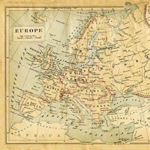
Canvas Print : Map of North America 1867


![]()
Canvas Prints from Fine Art Storehouse
Map of North America 1867
Map of North America - Warren geography 1867
Unleash your creativity and transform your space into a visual masterpiece!
THEPALMER
Media ID 20773089
20"x16" (51x41cm) Canvas Print
Discover history with our exquisite Canvas Print of the Map of North America from 1867 by THEPALMER, available in the Media Storehouse Fine Art Collection. This captivating piece, depicting Warren's Geography of North America from 1867, adds a touch of vintage charm and intellectual sophistication to any space. The intricate details of the map are beautifully rendered in high-quality canvas, ensuring a stunning visual experience. Bring history to life in your home or office with this unique and captivating work of art.
Delivered stretched and ready to hang our premium quality canvas prints are made from a polyester/cotton blend canvas and stretched over a 1.25" (32mm) kiln dried knot free wood stretcher bar. Packaged in a plastic bag and secured to a cardboard insert for safe transit.
Canvas Prints add colour, depth and texture to any space. Professionally Stretched Canvas over a hidden Wooden Box Frame and Ready to Hang
Estimated Product Size is 40.6cm x 50.8cm (16" x 20")
These are individually made so all sizes are approximate
Artwork printed orientated as per the preview above, with portrait (vertical) orientation to match the source image.
FEATURES IN THESE COLLECTIONS
> Maps and Charts
> Related Images
> North America
> Related Images
EDITORS COMMENTS
This print titled "Map of North America 1867" takes us back in time to the fascinating world of cartography. Created by THEPALMER, this piece showcases a meticulously detailed map that was originally published in 1867 by Warren geography. The map itself is a testament to the artistry and precision involved in creating such intricate geographical representations during that era. As we gaze upon this vintage masterpiece, we are transported to an era where exploration and discovery were at their peak. Every contour, river, mountain range, and city is delicately etched onto the paper, offering us a glimpse into the past and reminding us of how our understanding of the world has evolved over time. The sepia tones add a touch of nostalgia to this print, enhancing its historical charm. It serves as both an educational tool for those interested in studying the evolution of North America's borders and geography while also functioning as a stunning piece of artwork suitable for any space. Whether displayed in a study or hung on a living room wall, this print invites viewers to embark on their own journey through history. It sparks curiosity about what life was like during that period and encourages contemplation about how far we have come since then. "The Map of North America 1867" is not just an image; it's an invitation to explore our collective past while appreciating the beauty found within historical artifacts.
MADE IN AUSTRALIA
Safe Shipping with 30 Day Money Back Guarantee
FREE PERSONALISATION*
We are proud to offer a range of customisation features including Personalised Captions, Color Filters and Picture Zoom Tools
SECURE PAYMENTS
We happily accept a wide range of payment options so you can pay for the things you need in the way that is most convenient for you
* Options may vary by product and licensing agreement. Zoomed Pictures can be adjusted in the Cart.