Canvas Print > Historic > Colonial America illustrations > American colonies
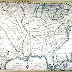
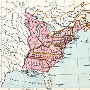
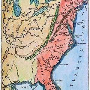
Canvas Print : COLONIAL AMERICA MAP. A map of the thirteen original American colonies, mid-18th century. Line engraving, late 19th century


![]()
Canvas Prints from Granger
COLONIAL AMERICA MAP. A map of the thirteen original American colonies, mid-18th century. Line engraving, late 19th century
Granger holds millions of images spanning more than 25,000 years of world history, from before the Stone Age to the dawn of the Space Age
Media ID 7506727
30"x20" (76x51cm) Canvas Print
Step back in time with our Colonial America Map Canvas Print, a captivating piece from The Granger Collection. This exquisite line engraving, originally produced in the late 19th century, showcases a detailed map of the thirteen original American colonies as they existed in the mid-18th century. Add historical charm to your home or office with this beautifully printed and framed canvas, perfect for history enthusiasts and those who appreciate the rich tapestry of American history.
Delivered stretched and ready to hang our premium quality canvas prints are made from a polyester/cotton blend canvas and stretched over a 1.25" (32mm) kiln dried knot free wood stretcher bar. Packaged in a plastic bag and secured to a cardboard insert for safe transit.
Canvas Prints add colour, depth and texture to any space. Professionally Stretched Canvas over a hidden Wooden Box Frame and Ready to Hang
Estimated Product Size is 50.8cm x 76.2cm (20" x 30")
These are individually made so all sizes are approximate
Artwork printed orientated as per the preview above, with portrait (vertical) orientation to match the source image.
FEATURES IN THESE COLLECTIONS
> Historic
> Colonial America illustrations
> 18th century America
> Historic
> Colonial America illustrations
> American colonies
> Historic
> Colonial America illustrations
> Colonial America
> Maps and Charts
> Related Images
> Granger Art on Demand
> Maps
EDITORS COMMENTS
This print showcases a historical treasure - the Colonial America Map. Created in the mid-18th century, this line engraving from the late 19th century offers a glimpse into the thirteen original American colonies that laid the foundation for modern-day United States. The intricate details and craftsmanship of this map are truly remarkable. As we explore this piece, we are transported back in time to an era when America was still emerging as a nation. The map highlights major rivers that played crucial roles in shaping early settlements and trade routes across these colonies. It serves as a testament to the adventurous spirit and determination of those who ventured into uncharted territories. The Granger Collection has expertly preserved this invaluable artifact, allowing us to appreciate its historical significance today. This print is not just an artwork; it is a window into our past, reminding us of our roots and how far we have come as a nation. Whether you are an avid history enthusiast or simply curious about America's colonial heritage, this print will undoubtedly captivate your imagination. Display it proudly on your wall or use it as an educational tool to spark conversations about our rich cultural heritage with friends and family. Join us on a journey through time with this extraordinary Colonial America Map from Granger Art on Demand!
MADE IN AUSTRALIA
Safe Shipping with 30 Day Money Back Guarantee
FREE PERSONALISATION*
We are proud to offer a range of customisation features including Personalised Captions, Color Filters and Picture Zoom Tools
SECURE PAYMENTS
We happily accept a wide range of payment options so you can pay for the things you need in the way that is most convenient for you
* Options may vary by product and licensing agreement. Zoomed Pictures can be adjusted in the Cart.