Jigsaw Puzzle > Historic > Colonial America illustrations > American colonies
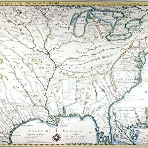
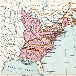
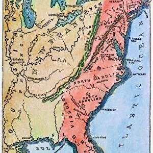
Jigsaw Puzzle : COLONIAL AMERICA MAP. A map of the thirteen original American colonies, mid-18th century. Line engraving, late 19th century


![]()
Jigsaw Puzzles from Granger
COLONIAL AMERICA MAP. A map of the thirteen original American colonies, mid-18th century. Line engraving, late 19th century
Granger holds millions of images spanning more than 25,000 years of world history, from before the Stone Age to the dawn of the Space Age
Media ID 7506727
Jigsaw Puzzle (1000 Pieces)
Discover the rich history of Colonial America with our exquisite jigsaw puzzle from Media Storehouse. Featuring a captivating map of the thirteen original American colonies from the mid-18th century, this intricately detailed puzzle is based on a line engraving from The Granger Collection. Immerse yourself in the past as you piece together this beautiful work of art, bringing the stories of the founding of our nation right to your living room. Perfect for history enthusiasts, puzzle lovers, or anyone seeking a challenging and rewarding pastime.
1000 piece puzzles are custom made in Australia and hand-finished on 100% recycled 1.6mm thick laminated puzzle boards. There is a level of repetition in jigsaw shapes with each matching piece away from its pair. The completed puzzle measures 76x50cm and is delivered packaged in an attractive presentation box specially designed to fit most mail slots with a unique magnetic lid
Jigsaw Puzzles are an ideal gift for any occasion
Estimated Product Size is 50.2cm x 76cm (19.8" x 29.9")
These are individually made so all sizes are approximate
Artwork printed orientated as per the preview above, with landscape (horizontal) or portrait (vertical) orientation to match the source image.
FEATURES IN THESE COLLECTIONS
> Granger Art on Demand
> Maps
> Historic
> Colonial America illustrations
> 18th century America
> Historic
> Colonial America illustrations
> American colonies
> Historic
> Colonial America illustrations
> Colonial America
> Maps and Charts
> Related Images
EDITORS COMMENTS
This print showcases a historical treasure - the Colonial America Map. Created in the mid-18th century, this line engraving from the late 19th century offers a glimpse into the thirteen original American colonies that laid the foundation for modern-day United States. The intricate details and craftsmanship of this map are truly remarkable. As we explore this piece, we are transported back in time to an era when America was still emerging as a nation. The map highlights major rivers that played crucial roles in shaping early settlements and trade routes across these colonies. It serves as a testament to the adventurous spirit and determination of those who ventured into uncharted territories. The Granger Collection has expertly preserved this invaluable artifact, allowing us to appreciate its historical significance today. This print is not just an artwork; it is a window into our past, reminding us of our roots and how far we have come as a nation. Whether you are an avid history enthusiast or simply curious about America's colonial heritage, this print will undoubtedly captivate your imagination. Display it proudly on your wall or use it as an educational tool to spark conversations about our rich cultural heritage with friends and family. Join us on a journey through time with this extraordinary Colonial America Map from Granger Art on Demand!
MADE IN AUSTRALIA
Safe Shipping with 30 Day Money Back Guarantee
FREE PERSONALISATION*
We are proud to offer a range of customisation features including Personalised Captions, Color Filters and Picture Zoom Tools
SECURE PAYMENTS
We happily accept a wide range of payment options so you can pay for the things you need in the way that is most convenient for you
* Options may vary by product and licensing agreement. Zoomed Pictures can be adjusted in the Cart.