Canvas Print > Africa > South Africa > Maps
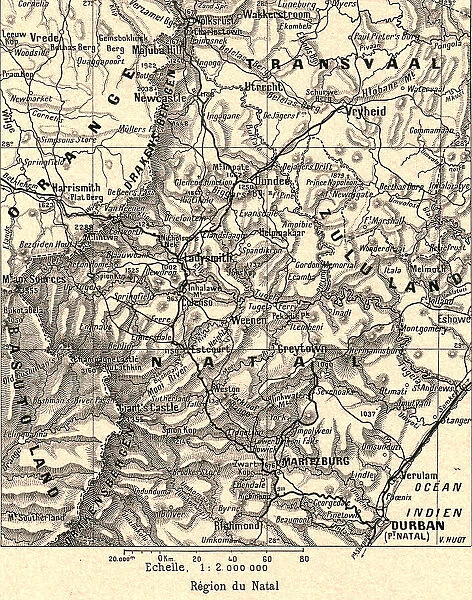
Canvas Print : Region du Natal; Afrique Australe, 1914. Creator: Unknown


![]()
Canvas Prints from Heritage Images
Region du Natal; Afrique Australe, 1914. Creator: Unknown
Region du Natal; Afrique Australe, 1914. From "Grande Geographie Bong Illustree", 1914
Heritage Images features heritage image collections
Media ID 36296677
© The Print Collector/Heritage Images
Cartography Geological Map Map Making Mapmaking Natal South Africa South Africa
20"x16" (51x41cm) Canvas Print
Step back in time with our exquisite Canvas Print of "Region du Natal; Afrique Australe," 1914, from Heritage Images. This captivating vintage image, originally published in Grande Geographie Bong Illustree, transports you to a bygone era in Africa's southern region. The high-quality canvas print brings the rich colors and intricate details of this unknown creator's work to life, making it a stunning addition to any home or office decor. Relive history with this beautiful and mysterious piece, now available as a canvas print from Media Storehouse.
Delivered stretched and ready to hang our premium quality canvas prints are made from a polyester/cotton blend canvas and stretched over a 1.25" (32mm) kiln dried knot free wood stretcher bar. Packaged in a plastic bag and secured to a cardboard insert for safe transit.
Canvas Prints add colour, depth and texture to any space. Professionally Stretched Canvas over a hidden Wooden Box Frame and Ready to Hang
Estimated Product Size is 40.6cm x 50.8cm (16" x 20")
These are individually made so all sizes are approximate
Artwork printed orientated as per the preview above, with portrait (vertical) orientation to match the source image.
FEATURES IN THESE COLLECTIONS
> Africa
> South Africa
> Maps
> Africa
> South Africa
> Related Images
> Maps and Charts
> Geological Map
> Maps and Charts
> Related Images
EDITORS COMMENTS
This vintage map print, titled "Region du Natal; Afrique Australe" from the 1914 edition of "Grande Geographie Bong Illustree," showcases the intricate geographical details of the Natal region in South Africa during the early 20th century. The map is a testament to the advancements in cartography and geological understanding during this era. The map is richly colored and detailed, with various geographical features labeled in both French and English. The Natal region, located on the eastern coast of South Africa, is depicted with an impressive level of accuracy, highlighting its topographical features, including the Drakensberg Mountains, the Uthukela and Mzinyathi rivers, and the Indian Ocean. The map also includes an inset of the Transvaal and Orange Free State provinces, providing a broader view of the surrounding areas. The intricate detailing of the map is a reflection of the meticulous work that went into its creation, showcasing the dedication and expertise of the mapmakers of the time. The "Region du Natal; Afrique Australe" map is a fascinating glimpse into the past, offering a unique perspective on the geographical knowledge of the early 20th century. Its vibrant colors and intricate detailing make it a stunning addition to any collection of vintage maps or Africana. The provenance of this map is unknown, but it is believed to have been published in France, reflecting the global reach of European cartography during this period. The map serves as a reminder of the rich history of mapmaking and the importance of geographical knowledge in shaping our understanding of the world around us.
MADE IN AUSTRALIA
Safe Shipping with 30 Day Money Back Guarantee
FREE PERSONALISATION*
We are proud to offer a range of customisation features including Personalised Captions, Color Filters and Picture Zoom Tools
SECURE PAYMENTS
We happily accept a wide range of payment options so you can pay for the things you need in the way that is most convenient for you
* Options may vary by product and licensing agreement. Zoomed Pictures can be adjusted in the Cart.