Canvas Print > Arts > Artists > T > John Tallis
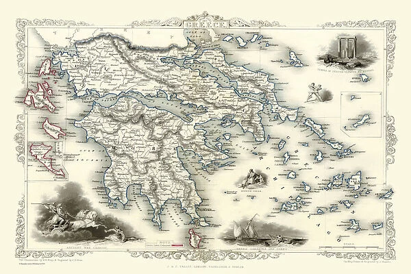
Canvas Print : Greece 1851


![]()
Canvas Prints from MapSeeker
Greece 1851
A fine facimile artworked from an antique original map of Greece, issued as part of the 1851 edition of John Tallis and Companys " The Illustrated Atlas and Modern History of the World"
Welcome to the Mapseeker Image library and enter an historic gateway to one of the largest on-line collections of Historic Maps, Nostalgic Views, Vista's and Panorama's from a World gone by.
Media ID 20347495
© Mapseeker Publishing Ltd
John Tallis John Tallis Map Tallis Map
30"x20" (76x51cm) Canvas Print
Experience the rich history of Greece with our exquisite Canvas Print of "Greece 1851" by John Tallis and John Rapkin from MapSeeker. This stunning facsimile artwork is meticulously reproduced from an original map published in the 1851 edition of "The Illustrated Atlas and Modern History of the World." The intricate details and vibrant colors bring the history of Greece to life, making it a beautiful addition to any home or office. Our high-quality Canvas Print is made to last, with a durable finish that ensures your artwork maintains its brilliance for years to come. Transport yourself to a world of ancient civilizations and legendary tales with this captivating piece of cartographic history.
Delivered stretched and ready to hang our premium quality canvas prints are made from a polyester/cotton blend canvas and stretched over a 1.25" (32mm) kiln dried knot free wood stretcher bar. Packaged in a plastic bag and secured to a cardboard insert for safe transit.
Canvas Prints add colour, depth and texture to any space. Professionally Stretched Canvas over a hidden Wooden Box Frame and Ready to Hang
Estimated Product Size is 76.2cm x 50.8cm (30" x 20")
These are individually made so all sizes are approximate
Artwork printed orientated as per the preview above, with landscape (horizontal) orientation to match the source image.
FEATURES IN THESE COLLECTIONS
> Arts
> Artists
> T
> John Tallis
> Europe
> Greece
> Related Images
> Historic
> Ancient civilizations
> Ancient Greece
> Greek history
> Maps and Charts
> Related Images
> Maps and Charts
> World
> MapSeeker
> Maps of Europe
> Maps of Greece PORTFOLIO
EDITORS COMMENTS
This stunning print showcases a fine facsimile artwork of an antique original map of Greece from the year 1851. The map was originally issued as part of John Tallis and Company's renowned publication, "The Illustrated Atlas and Modern History of the World". Capturing the essence of historical cartography, this old map takes us back in time to explore the intricate details and boundaries that defined Greece during that era. With its delicate craftsmanship and meticulous attention to geographical accuracy, it offers a glimpse into how our understanding of this ancient civilization has evolved over time. The artistry behind this reproduction is truly remarkable, as every contour line, river system, and city placement has been faithfully recreated. This piece allows us to appreciate not only the beauty but also the significance of maps as tools for exploration and knowledge dissemination. As we gaze upon this vintage Greek map by John Tallis and John Rapkin, we are transported to a different era where these detailed illustrations were essential for navigation purposes or simply satisfying one's curiosity about distant lands. It serves as a reminder that even in today's digital age, there is still something enchanting about holding a physical representation of history in our hands.
MADE IN AUSTRALIA
Safe Shipping with 30 Day Money Back Guarantee
FREE PERSONALISATION*
We are proud to offer a range of customisation features including Personalised Captions, Color Filters and Picture Zoom Tools
SECURE PAYMENTS
We happily accept a wide range of payment options so you can pay for the things you need in the way that is most convenient for you
* Options may vary by product and licensing agreement. Zoomed Pictures can be adjusted in the Cart.