Canvas Print > Europe > France > Paris > Maps
Canvas Print : Elysee Palace - map


![]()
Canvas Prints from Mary Evans Picture Library
Elysee Palace - map
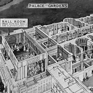
A plan of the Elysee Palace, Paris. Date: 1913
Mary Evans Picture Library makes available wonderful images created for people to enjoy over the centuries
Media ID 14117881
© Mary Evans Picture Library
30"x20" (76x51cm) Canvas Print
Transform your home or office into a gallery with our exquisite Canvas Prints from Media Storehouse. This particular piece showcases an intriguing historical map of the iconic Elysee Palace in Paris, dated 1913. Meticulously sourced from Mary Evans Prints Online, this Rights Managed image brings a touch of European elegance and rich history to your space. Our high-quality canvas prints are not only visually striking but also durable, ensuring your investment in art lasts a lifetime. Experience the beauty and sophistication of this detailed map of the Elysee Palace and elevate your interior design with Media Storehouse Canvas Prints.
Delivered stretched and ready to hang our premium quality canvas prints are made from a polyester/cotton blend canvas and stretched over a 1.25" (32mm) kiln dried knot free wood stretcher bar. Packaged in a plastic bag and secured to a cardboard insert for safe transit.
Canvas Prints add colour, depth and texture to any space. Professionally Stretched Canvas over a hidden Wooden Box Frame and Ready to Hang
Estimated Product Size is 76.2cm x 50.8cm (30" x 20")
These are individually made so all sizes are approximate
Artwork printed orientated as per the preview above, with landscape (horizontal) orientation to match the source image.
FEATURES IN THESE COLLECTIONS
> Europe
> France
> Paris
> Maps
> Europe
> France
> Paris
> Related Images
> Maps and Charts
> Early Maps
> Maps and Charts
> Related Images
EDITORS COMMENTS
1. Title: A Glance into the Past: The Elysée Palace Map of 1913, Paris The Elysée Palace, a historic landmark in Paris, France, has been the official residence and workplace of the French President since 1873. This image showcases a meticulously detailed map of the Elysée Palace, as it appeared in 1913. This rare and intriguing artifact, sourced from Mary Evans Prints Online, offers a unique perspective on the palace's rich history. The map, created over a century ago, reveals the layout of the palace as it stood during that era. It highlights various sections such as the Grand Salon, the Salon de Marbre, the Salon de l'Horloge, and the Salon de la Paix, which have since become iconic spaces within the palace. The map also reveals the presence of several gardens, including the Jardin d'Hiver and the Jardin Secret, which have undergone significant transformations over the years. The Elysée Palace, with its grand architecture and beautiful gardens, has been a symbol of French political power and prestige. It has played host to numerous historic events, including peace treaties, state visits, and diplomatic meetings. The map serves as a testament to the palace's enduring significance in French history and culture. As we examine this map of the Elysée Palace from over a century ago, we are transported back in time, offering us a fascinating glimpse into the past. It invites us to explore the history of this iconic Parisian landmark and appreciate the evolution it has undergone over the years.
MADE IN AUSTRALIA
Safe Shipping with 30 Day Money Back Guarantee
FREE PERSONALISATION*
We are proud to offer a range of customisation features including Personalised Captions, Color Filters and Picture Zoom Tools
SECURE PAYMENTS
We happily accept a wide range of payment options so you can pay for the things you need in the way that is most convenient for you
* Options may vary by product and licensing agreement. Zoomed Pictures can be adjusted in the Cart.