Canvas Print > Historic > Ancient civilizations > Ancient Greece > Athens
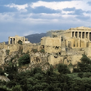
Canvas Print : Perspective view of the plan of Athens, Greece 1700 Date: 1700


![]()
Canvas Prints from Mary Evans Picture Library
Perspective view of the plan of Athens, Greece 1700 Date: 1700
Mary Evans Picture Library makes available wonderful images created for people to enjoy over the centuries
Media ID 20247561
© Pictures Now Image Collection / Bubblepunk
1700 Antiquarian Antique Athens Journey Journeys Maps Perspective Plan Travels Treks Trip Trips Voyage Voyages
20"x16" (51x41cm) Canvas Print
Step back in time with our exquisite Canvas Print of the Perspective View of the Plan of Athens, Greece (1700), from Mary Evans Prints Online. This stunning piece of historical art transports you to ancient Greece with its intricate depiction of Athens as it appeared over three centuries ago. The use of high-quality canvas and vibrant colors brings the details of this 1700 map to life, making it a captivating addition to any home or office. Relive the rich history of Athens and add a touch of timeless elegance to your space with our Canvas Print. #Athens #Greece #HistoricalArt #CanvasPrint
Delivered stretched and ready to hang our premium quality canvas prints are made from a polyester/cotton blend canvas and stretched over a 1.25" (32mm) kiln dried knot free wood stretcher bar. Packaged in a plastic bag and secured to a cardboard insert for safe transit.
Canvas Prints add colour, depth and texture to any space. Professionally Stretched Canvas over a hidden Wooden Box Frame and Ready to Hang
Estimated Product Size is 50.8cm x 40.6cm (20" x 16")
These are individually made so all sizes are approximate
Artwork printed orientated as per the preview above, with landscape (horizontal) orientation to match the source image.
FEATURES IN THESE COLLECTIONS
> Europe
> Greece
> Related Images
> Europe
> Related Images
> Historic
> Ancient civilizations
> Ancient Greece
> Athens
> Historic
> Ancient civilizations
> Ancient Greece
> Greek history
> Maps and Charts
> Early Maps
> Maps and Charts
> Related Images
> Mary Evans Prints Online
> Pictures Now
EDITORS COMMENTS
This perspective view of Athens, Greece, dates back to the year 1700. The antique map offers a unique and intriguing glimpse into the historical layout of the ancient city, with its labyrinthine streets and iconic landmarks. The meticulously drawn plan invites us on a journey through time, transporting us back to an era when Athens was a thriving center of culture and knowledge in Europe. The map's intricate details reveal the Acropolis, the ancient citadel located on a rocky outcrop, dominating the cityscape. The Parthenon, the iconic temple dedicated to Athena, is prominently featured, as are other notable structures such as the Propylaea, the Erechtheion, and the Odeon of Herodes Atticus. The map also highlights the Agora, the heart of ancient Athenian public life, and the Kerameikos, the ancient cemetery. The perspective view adds depth and dimension to the map, allowing us to visualize the city's topography and the relationship between its various landmarks. The use of shading and shadows enhances the three-dimensional effect, making it easier to navigate the complex urban layout. This antiquarian map is a testament to the rich history of Athens and the enduring fascination it holds for travelers and historians alike. It invites us to explore the city's past and imagine the journeys and voyages that have shaped its story over the centuries.
MADE IN AUSTRALIA
Safe Shipping with 30 Day Money Back Guarantee
FREE PERSONALISATION*
We are proud to offer a range of customisation features including Personalised Captions, Color Filters and Picture Zoom Tools
SECURE PAYMENTS
We happily accept a wide range of payment options so you can pay for the things you need in the way that is most convenient for you
* Options may vary by product and licensing agreement. Zoomed Pictures can be adjusted in the Cart.