Framed Print > Historic > Ancient civilizations > Ancient Greece > Athens
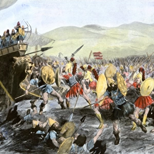
Framed Print : Perspective view of the plan of Athens, Greece 1700 Date: 1700


![]()
Framed Photos from Mary Evans Picture Library
Perspective view of the plan of Athens, Greece 1700 Date: 1700
Mary Evans Picture Library makes available wonderful images created for people to enjoy over the centuries
Media ID 20247561
© Pictures Now Image Collection / Bubblepunk
1700 Antiquarian Antique Athens Journey Journeys Maps Perspective Plan Travels Treks Trip Trips Voyage Voyages
13.5"x11.5" (34x29cm) Premium Frame
Step back in time with our exquisite Framed Print from Media Storehouse, featuring a captivating perspective view of Athens, Greece, dating back to 1700. This beautifully detailed map, sourced from Mary Evans Prints Online, offers a unique glimpse into the ancient city's layout during the early modern period. Each print is meticulously framed with care, enhancing the intricate lines and subtle shading of this historical treasure. Add an air of sophistication and history to your living space with this stunning addition to your collection.
Framed and mounted 9x7 print. Professionally handmade full timber moulded frames are finished off with framers tape and come with a hanging solution on the back. Outer dimensions are 13.5x11.5 inches (34x29cm). Quality timber frame frame moulding (20mm wide and 30mm deep) with frame colours in your choice of black, white, or raw oak and a choice of black or white card mounts. Frames have a perspex front providing a virtually unbreakable glass-like finish which is easily cleaned with a damp cloth.
Contemporary Framed and Mounted Prints - Professionally Made and Ready to Hang
Estimated Image Size (if not cropped) is 21.4cm x 21.4cm (8.4" x 8.4")
Estimated Product Size is 34cm x 29.2cm (13.4" x 11.5")
These are individually made so all sizes are approximate
Artwork printed orientated as per the preview above, with landscape (horizontal) or portrait (vertical) orientation to match the source image.
FEATURES IN THESE COLLECTIONS
> Europe
> Greece
> Related Images
> Europe
> Related Images
> Historic
> Ancient civilizations
> Ancient Greece
> Athens
> Historic
> Ancient civilizations
> Ancient Greece
> Greek history
> Maps and Charts
> Early Maps
> Maps and Charts
> Related Images
> Mary Evans Prints Online
> Pictures Now
EDITORS COMMENTS
This perspective view of Athens, Greece, dates back to the year 1700. The antique map offers a unique and intriguing glimpse into the historical layout of the ancient city, with its labyrinthine streets and iconic landmarks. The meticulously drawn plan invites us on a journey through time, transporting us back to an era when Athens was a thriving center of culture and knowledge in Europe. The map's intricate details reveal the Acropolis, the ancient citadel located on a rocky outcrop, dominating the cityscape. The Parthenon, the iconic temple dedicated to Athena, is prominently featured, as are other notable structures such as the Propylaea, the Erechtheion, and the Odeon of Herodes Atticus. The map also highlights the Agora, the heart of ancient Athenian public life, and the Kerameikos, the ancient cemetery. The perspective view adds depth and dimension to the map, allowing us to visualize the city's topography and the relationship between its various landmarks. The use of shading and shadows enhances the three-dimensional effect, making it easier to navigate the complex urban layout. This antiquarian map is a testament to the rich history of Athens and the enduring fascination it holds for travelers and historians alike. It invites us to explore the city's past and imagine the journeys and voyages that have shaped its story over the centuries.
MADE IN AUSTRALIA
Safe Shipping with 30 Day Money Back Guarantee
FREE PERSONALISATION*
We are proud to offer a range of customisation features including Personalised Captions, Color Filters and Picture Zoom Tools
SECURE PAYMENTS
We happily accept a wide range of payment options so you can pay for the things you need in the way that is most convenient for you
* Options may vary by product and licensing agreement. Zoomed Pictures can be adjusted in the Cart.