Canvas Print > Arts > Artists > O > Oceanic Oceanic
Canvas Print : Strategic importance of Crete and Cyprus by G. H. Davis


![]()
Canvas Prints from Mary Evans Picture Library
Strategic importance of Crete and Cyprus by G. H. Davis
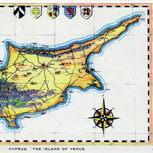
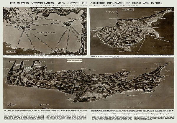
The Eastern Mediterranean: maps showing the strategic importance of Crete and Cyprus during the Second World War. Date: 1941
Mary Evans Picture Library makes available wonderful images created for people to enjoy over the centuries
Media ID 14125625
© Illustrated London News Ltd/Mary Evans
1941 Crete Cyprus Davis Importance Important Maps Mediterranean Strategic Strategy
30"x20" (76x51cm) Canvas Print
Introducing the Media Storehouse Canvas Prints featuring "Strategic Importance of Crete and Cyprus by G. H. Davis." This captivating vintage map, sourced from Mary Evans Prints Online, dates back to 1941 and provides a unique insight into the Eastern Mediterranean's strategic importance during the Second World War. This beautifully detailed map showcases Crete and Cyprus, two key locations that played pivotal roles in the war's Mediterranean theater. The intricate cartography, combined with the historical significance, makes this an excellent addition to any home or office. Our high-quality canvas prints are meticulously crafted to bring out the rich colors and details of this historic map. Each print is coated with a protective varnish to preserve its beauty and ensure it remains a cherished piece for generations to come. Experience the perfect blend of history and artistry with the Media Storehouse Canvas Print of "Strategic Importance of Crete and Cyprus by G. H. Davis." Order yours today and add a touch of historical intrigue to your space.
Delivered stretched and ready to hang our premium quality canvas prints are made from a polyester/cotton blend canvas and stretched over a 1.25" (32mm) kiln dried knot free wood stretcher bar. Packaged in a plastic bag and secured to a cardboard insert for safe transit.
Canvas Prints add colour, depth and texture to any space. Professionally Stretched Canvas over a hidden Wooden Box Frame and Ready to Hang
Estimated Product Size is 76.2cm x 50.8cm (30" x 20")
These are individually made so all sizes are approximate
Artwork printed orientated as per the preview above, with landscape (horizontal) orientation to match the source image.
FEATURES IN THESE COLLECTIONS
> Arts
> Artists
> O
> Oceanic Oceanic
> Asia
> Cyprus
> Related Images
> Maps and Charts
> Early Maps
> Maps and Charts
> Related Images
> Maps and Charts
> World
EDITORS COMMENTS
This map print, titled "The Eastern Mediterranean: Maps Showing the Strategic Importance of Crete and Cyprus during the Second World War," is a historical testament to the pivotal role these islands played in the Mediterranean Theatre of World War II. Created by cartographer G. H. Davis in 1941, the map offers a unique perspective on the geopolitical significance of Crete and Cyprus during this tumultuous period. The Eastern Mediterranean Sea, a vital oceanic artery connecting Europe, Africa, and the Middle East, is depicted in stunning detail. The map highlights the strategic importance of the islands of Crete and Cyprus, located at the eastern end of the Mediterranean. The annotations and illustrations provide valuable context, revealing the military installations, shipping lanes, and communication routes that crisscrossed the region. During World War II, Crete and Cyprus were of great strategic importance due to their proximity to key shipping lanes and their potential as military bases. In May 1941, the German forces launched a successful invasion of Crete, which marked the last major Axis seizure of territory in the Mediterranean. The fall of Crete threatened the Allied supply lines and forced a reevaluation of their defensive strategy in the region. Cyprus, on the other hand, remained under British control throughout the war and served as a crucial base for the Royal Navy, Royal Air Force, and the American military. The island's strategic position allowed it to protect the eastern Mediterranean from Axis influence and secure the vital sea lanes that connected the Middle East to Europe. This map print is an essential addition to any collection focused on World War II, military history, or cartography. It offers a captivating glimpse into the strategic considerations that shaped the course of the war in the Mediterranean and highlights the enduring significance of these islands in the broader historical context.
MADE IN AUSTRALIA
Safe Shipping with 30 Day Money Back Guarantee
FREE PERSONALISATION*
We are proud to offer a range of customisation features including Personalised Captions, Color Filters and Picture Zoom Tools
SECURE PAYMENTS
We happily accept a wide range of payment options so you can pay for the things you need in the way that is most convenient for you
* Options may vary by product and licensing agreement. Zoomed Pictures can be adjusted in the Cart.