Framed Print > Arts > Artists > O > Oceanic Oceanic
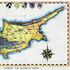
Framed Print : Strategic importance of Crete and Cyprus by G. H. Davis


![]()
Framed Photos from Mary Evans Picture Library
Strategic importance of Crete and Cyprus by G. H. Davis
The Eastern Mediterranean: maps showing the strategic importance of Crete and Cyprus during the Second World War. Date: 1941
Mary Evans Picture Library makes available wonderful images created for people to enjoy over the centuries
Media ID 14125625
© Illustrated London News Ltd/Mary Evans
1941 Crete Cyprus Davis Importance Important Maps Mediterranean Strategic Strategy
A2 Premium Frame with A3 Poster
Introducing the Media Storehouse Framed Print collection, featuring the captivating "Strategic Importance of Crete and Cyprus by G. H. Davis." This vintage map, sourced from Mary Evans Prints Online, takes you back to 1941 during the Second World War. This intricately detailed and historically significant map highlights the strategic importance of Crete and Cyprus in the Eastern Mediterranean. The rich colors and meticulous details are brought to life within a beautifully crafted frame, making this print an essential addition to any office, study, or history enthusiast's space. Immerse yourself in the history of this pivotal time in world history with the Media Storehouse Framed Print of "Strategic Importance of Crete and Cyprus by G. H. Davis."
Premium Paradise Wooden Range A2 Premium Poster Frame (62x45cm) with A3 Poster (42x30cm) and mounted behind a white matt board to make your photo really stand out. FSC Certified and Rainforest Alliance Certified for environmental, social, and economic sustainably. High transparency tempered glass window with a smooth finished frame. Great for filling empty walls, decorating blank spaces, or creating eye-catching gallery walls. Frames arrive ready to hang. Sent with secure, protective packaging. Smooth wooden veneer mimics the real wood look and feel with ultra-durable scratch resistance tempered glass.
Contemporary Framed and Mounted Prints - Professionally Made and Ready to Hang
Estimated Image Size (if not cropped) is 40.4cm x 40.4cm (15.9" x 15.9")
Estimated Product Size is 62cm x 44.6cm (24.4" x 17.6")
These are individually made so all sizes are approximate
Artwork printed orientated as per the preview above, with landscape (horizontal) or portrait (vertical) orientation to match the source image.
FEATURES IN THESE COLLECTIONS
> Arts
> Artists
> O
> Oceanic Oceanic
> Asia
> Cyprus
> Related Images
> Maps and Charts
> Early Maps
> Maps and Charts
> Related Images
> Maps and Charts
> World
EDITORS COMMENTS
This map print, titled "The Eastern Mediterranean: Maps Showing the Strategic Importance of Crete and Cyprus during the Second World War," is a historical testament to the pivotal role these islands played in the Mediterranean Theatre of World War II. Created by cartographer G. H. Davis in 1941, the map offers a unique perspective on the geopolitical significance of Crete and Cyprus during this tumultuous period. The Eastern Mediterranean Sea, a vital oceanic artery connecting Europe, Africa, and the Middle East, is depicted in stunning detail. The map highlights the strategic importance of the islands of Crete and Cyprus, located at the eastern end of the Mediterranean. The annotations and illustrations provide valuable context, revealing the military installations, shipping lanes, and communication routes that crisscrossed the region. During World War II, Crete and Cyprus were of great strategic importance due to their proximity to key shipping lanes and their potential as military bases. In May 1941, the German forces launched a successful invasion of Crete, which marked the last major Axis seizure of territory in the Mediterranean. The fall of Crete threatened the Allied supply lines and forced a reevaluation of their defensive strategy in the region. Cyprus, on the other hand, remained under British control throughout the war and served as a crucial base for the Royal Navy, Royal Air Force, and the American military. The island's strategic position allowed it to protect the eastern Mediterranean from Axis influence and secure the vital sea lanes that connected the Middle East to Europe. This map print is an essential addition to any collection focused on World War II, military history, or cartography. It offers a captivating glimpse into the strategic considerations that shaped the course of the war in the Mediterranean and highlights the enduring significance of these islands in the broader historical context.
MADE IN AUSTRALIA
Safe Shipping with 30 Day Money Back Guarantee
FREE PERSONALISATION*
We are proud to offer a range of customisation features including Personalised Captions, Color Filters and Picture Zoom Tools
SECURE PAYMENTS
We happily accept a wide range of payment options so you can pay for the things you need in the way that is most convenient for you
* Options may vary by product and licensing agreement. Zoomed Pictures can be adjusted in the Cart.