Canvas Print > Historic > Colonial history > Colonial art and artists
Canvas Print : East Jersey and West Jersey


![]()
Canvas Prints from North Wind
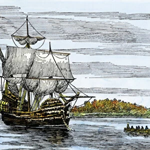
East Jersey and West Jersey
Map of colonial East and West Jersey, late 1600s.
Hand-colored woodcut of a 19th-century illustration
North Wind Picture Archives brings history to life with stock images and hand-colored illustrations
Media ID 5882571
© North Wind Picture Archives
1600s 17th Century British Colonial Colonist Colony English English Colony New Jersey
30"x20" (76x51cm) Canvas Print
Discover the rich history of colonial America with our stunning Canvas Prints from Media Storehouse, featuring the captivating map of "East Jersey and West Jersey" from North Wind Picture Archives. This intricately detailed, hand-colored woodcut illustration showcases the territories of East Jersey and West Jersey in the late 1600s. Bring the history of the colonial era into your home or office with this beautiful and authentic piece of art. Our high-quality canvas prints are expertly crafted to bring out the vibrant colors and intricate details of this historic map, creating a conversation piece that is sure to impress. Order yours today and step back in time to an era of exploration and discovery.
Delivered stretched and ready to hang our premium quality canvas prints are made from a polyester/cotton blend canvas and stretched over a 1.25" (32mm) kiln dried knot free wood stretcher bar. Packaged in a plastic bag and secured to a cardboard insert for safe transit.
Canvas Prints add colour, depth and texture to any space. Professionally Stretched Canvas over a hidden Wooden Box Frame and Ready to Hang
Estimated Product Size is 50.8cm x 76.2cm (20" x 30")
These are individually made so all sizes are approximate
Artwork printed orientated as per the preview above, with portrait (vertical) orientation to match the source image.
FEATURES IN THESE COLLECTIONS
> Historic
> Colonial America illustrations
> Colonial America
> Historic
> Colonial America illustrations
> Historic
> Colonial history
> Colonial art and artists
> North America
> Related Images
> North Wind Picture Archives
> Maps
EDITORS COMMENTS
This print showcases a remarkable piece of history - the map of colonial East and West Jersey from the late 1600s. With its hand-colored woodcut, this 19th-century illustration beautifully captures the essence of America's vintage heritage. Transporting us back in time, this historic artwork sheds light on the early days of English colonization in North America. As we gaze upon this intricate map, we can almost envision the brave colonists who ventured across vast oceans to establish their new lives in these uncharted territories. The detailed depiction highlights the division between East Jersey and West Jersey, two distinct regions that played crucial roles in shaping New Jersey's future. It serves as a testament to British influence during those times and reminds us of how different life was for our ancestors. This artful representation not only celebrates our shared history but also pays homage to the resilience and determination of those who paved the way for present-day United States. It is a visual reminder that beneath modern cities and bustling streets lies a rich tapestry woven by countless generations before us. As we admire this exquisite print, let it serve as an inspiration to explore further into our roots, appreciate our cultural heritage, and cherish the legacy left behind by those who came before us.
MADE IN AUSTRALIA
Safe Shipping with 30 Day Money Back Guarantee
FREE PERSONALISATION*
We are proud to offer a range of customisation features including Personalised Captions, Color Filters and Picture Zoom Tools
SECURE PAYMENTS
We happily accept a wide range of payment options so you can pay for the things you need in the way that is most convenient for you
* Options may vary by product and licensing agreement. Zoomed Pictures can be adjusted in the Cart.