Canvas Print > North America > United States of America > New York > New York > Maps
Canvas Print : Iroquois Nations map, 1600s


![]()
Canvas Prints from North Wind
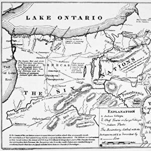
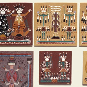
Iroquois Nations map, 1600s
French map of the Five Iroquois Nations homeland and Fort Orange (Albany), 1660s.
Hand-colored woodcut of a 17th-century illustration
North Wind Picture Archives brings history to life with stock images and hand-colored illustrations
Media ID 5882657
© North Wind Picture Archives
1600s 17th Century American Indian Amerindian Document East Eastern Indian Iroquois Iroquois Confederacy Lake Ontario Native Native American New York Onandaga Village 1660 Albany Cayuga Five Nations French Language Indian Village Iroquois Confederation Oneida Seneca
21"x7" (53x18cm) Canvas Print
Discover the rich history of the Iroquois Nations with our exquisite Canvas Print from Media Storehouse, featuring an authentic map from North Wind Picture Archives. Dating back to the 1600s, this captivating woodcut illustration depicts the homeland of the Five Iroquois Nations and Fort Orange (Albany) as seen by French explorers in the 1660s. Hand-colored for added detail and vibrancy, this canvas print is a stunning addition to any room, bringing history to life with its intricate design and timeless beauty.
Delivered stretched and ready to hang our premium quality canvas prints are made from a polyester/cotton blend canvas and stretched over a 1.25" (32mm) kiln dried knot free wood stretcher bar. Packaged in a plastic bag and secured to a cardboard insert for safe transit.
Canvas Prints add colour, depth and texture to any space. Professionally Stretched Canvas over a hidden Wooden Box Frame and Ready to Hang
Estimated Product Size is 53.3cm x 17.8cm (21" x 7")
These are individually made so all sizes are approximate
Artwork printed orientated as per the preview above, with landscape (horizontal) orientation to match the source image.
FEATURES IN THESE COLLECTIONS
> Europe
> France
> Lakes
> Related Images
> North America
> Related Images
> North America
> United States of America
> New York
> Albany
> North America
> United States of America
> New York
> New York
> Maps
> North America
> United States of America
> New York
> Related Images
> North Wind Picture Archives
> Maps
> North Wind Picture Archives
> Native Americans
EDITORS COMMENTS
This hand-colored woodcut print showcases a remarkable piece of history - the Iroquois Nations map from the 1600s. Created by French cartographers, this illustration beautifully depicts the homeland of the Five Iroquois Nations and Fort Orange (present-day Albany) in the 1660s. The intricate details of this vintage artwork transport us back to a time when Native American tribes thrived in what is now New York State. The map highlights the eastern region of North America, where these indigenous communities resided for centuries. The Iroquois Confederacy, also known as Haudenosaunee or "People of the Longhouse" consisted of five powerful nations: Seneca, Cayuga, Onondaga, Oneida, and Mohawk. This visual representation provides valuable insight into their interconnected territories and settlements. Lake Ontario serves as a prominent feature on this map, emphasizing its significance as a vital waterway for trade and transportation among these nations. It's fascinating to observe how each tribe had its own distinct village within their shared territory. As we gaze upon this historic document, we gain a deeper appreciation for the rich heritage and cultural legacy that shaped early America. Through artful strokes and vibrant colors, this illustration immortalizes an era when Native Americans lived harmoniously with nature while forging strong alliances within their confederacy.
MADE IN AUSTRALIA
Safe Shipping with 30 Day Money Back Guarantee
FREE PERSONALISATION*
We are proud to offer a range of customisation features including Personalised Captions, Color Filters and Picture Zoom Tools
SECURE PAYMENTS
We happily accept a wide range of payment options so you can pay for the things you need in the way that is most convenient for you
* Options may vary by product and licensing agreement. Zoomed Pictures can be adjusted in the Cart.