Canvas Print > Europe > United Kingdom > England > Yorkshire > Denton
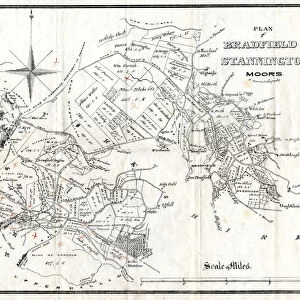
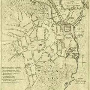
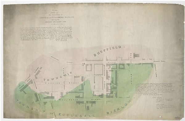
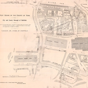
Canvas Print : Plan of part of the townships of Sheffield and Ecclesall Bierlow, shewing the ancient boundary line, 1835


![]()
Canvas Prints from Sheffield City Archives
Plan of part of the townships of Sheffield and Ecclesall Bierlow, shewing the ancient boundary line, 1835
By J. Fairbank and Son.
Also signed by W. Smith, Joshua Denton, Thomas Turner and Joseph Senior, Overseers of the Poor of Sheffield and Josiah Davy, John Smith, Samuel Mitchell and John Ward, Overseers of the Poor of Ecclesall Bierlow.
Shows Devonshire Street, Eldon Street, Broom Hall Street, Fitzwilliam Street, Bowdon Street, Wellington Street, Chester Street, Wellington Lane, Devonshire Lane, Trafalgar Street, Rockingham Street, Division Steet, Rockingham Lane, Carver Street, National School on Carver Street, Barker [sic] Pool, Coalpit Lane.
Dimensions of original approx. 100 x 64 cm.
From an original at Sheffield Libraries: arc04050
Sheffield City Archives and Local Studies Library has an unrivalled collection of images of Sheffield, England
Media ID 23122439
© Sheffield City Council - All Rights Reserved
30"x20" (76x51cm) Canvas Print
Step back in time with our exquisite Media Storehouse Canvas Print of "Plan of part of the townships of Sheffield and Ecclesall Bierlow, shewing the ancient boundary line, 1835." This rare and intriguing map, taken from the Sheffield City Archives, provides a captivating glimpse into the past. Carefully reproduced in vibrant detail on high-quality canvas, this piece showcases the meticulous work of J. Fairbank and Son, with signatures from key figures of the time including W. Smith, Joshua Denton, Thomas Turner, Joseph Senior, Josiah Davy, John Smith, Samuel Mitchell, and John Ward. Perfect for history enthusiasts, this unique and beautiful canvas print adds a touch of historical character to any room in your home or office.
Delivered stretched and ready to hang our premium quality canvas prints are made from a polyester/cotton blend canvas and stretched over a 1.25" (32mm) kiln dried knot free wood stretcher bar. Packaged in a plastic bag and secured to a cardboard insert for safe transit.
Canvas Prints add colour, depth and texture to any space. Professionally Stretched Canvas over a hidden Wooden Box Frame and Ready to Hang
Estimated Product Size is 76.2cm x 50.8cm (30" x 20")
These are individually made so all sizes are approximate
Artwork printed orientated as per the preview above, with landscape (horizontal) orientation to match the source image.
FEATURES IN THESE COLLECTIONS
> Arts
> Artists
> B
> John Barker
> Arts
> Artists
> L
> Samuel Lane
> Arts
> Artists
> S
> John Thomas Smith
> Europe
> United Kingdom
> England
> Yorkshire
> Denton
> Europe
> United Kingdom
> England
> Yorkshire
> Fitzwilliam
> Europe
> United Kingdom
> England
> Yorkshire
> Pool
> Europe
> United Kingdom
> England
> Yorkshire
> Related Images
> Europe
> United Kingdom
> England
> Yorkshire
> Sheffield
> Europe
> United Kingdom
> England
> Yorkshire
> Street
> Maps and Charts
> Early Maps
> Sheffield City Archives
> Maps and Plans
> Maps of Sheffield
EDITORS COMMENTS
This print takes us back to the year 1835, offering a glimpse into the historical townships of Sheffield and Ecclesall Bierlow. The intricate map, meticulously crafted by J. Fairbank and Son, showcases the ancient boundary line that once defined these vibrant communities. Signed by notable figures such as W. Smith, Joshua Denton, Thomas Turner, Joseph Senior from Sheffield's Overseers of the Poor and Josiah Davy, John Smith, Samuel Mitchell, and John Ward from Ecclesall Bierlow's Overseers of the Poor. As we delve into this remarkable piece of history preserved at Sheffield Libraries' archives (arc04050), our eyes wander through streets that have witnessed countless stories unfold over time. Devonshire Street stands tall alongside Eldon Street while Broom Hall Street intersects with Fitzwilliam Street in a bustling display of urban life. Bowdon Street leads us towards Wellington Lane and Chester Street before merging with Devonshire Lane. The map also highlights significant landmarks like Trafalgar Street and Rockingham Street along with their adjacent counterparts: Division Steet, Rockingham Lane, Carver Street - home to a National School - Barker Pool and Coalpit Lane. With its original dimensions measuring approximately 100 x 64 cm. , this print serves as an invaluable window into Sheffield's past for all who seek to explore its rich heritage. Let us cherish this visual treasure but remember not to use it for commercial purposes; instead appreciating it solely for its historical
MADE IN AUSTRALIA
Safe Shipping with 30 Day Money Back Guarantee
FREE PERSONALISATION*
We are proud to offer a range of customisation features including Personalised Captions, Color Filters and Picture Zoom Tools
SECURE PAYMENTS
We happily accept a wide range of payment options so you can pay for the things you need in the way that is most convenient for you
* Options may vary by product and licensing agreement. Zoomed Pictures can be adjusted in the Cart.
![Plan shewing the antient [sic] boundary line between part of the townships of Sheffield, Ecclesall and Nether Hallam, 1834](/sq/716/plan-shewing-antient-sic-boundary-line-23122477.jpg.webp)
![Maps of Several Parcels of Land proposed to be exchanged, Bradfield, [c. 1750 - 1760]](/sq/716/maps-parcels-land-proposed-exchanged-bradfield-19192402.jpg.webp)