Canvas Print > Historic > Ancient civilizations > Roman Empire > Roman emperors
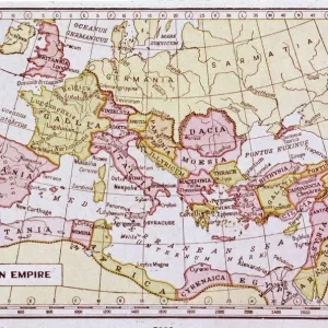
Canvas Print : Map of Roman empire under Emperor Diocletian rule (AD 284-305), drawing
, drawing")
, drawing")


![]()
Canvas Prints from Universal Images Group (UIG)
Map of Roman empire under Emperor Diocletian rule (AD 284-305), drawing
Ancient Rome. Map of Roman empire under Emperor Diocletian rule (AD 284-305). Color illustration
Universal Images Group (UIG) manages distribution for many leading specialist agencies worldwide
Media ID 9512173
3rd Century Aerial View Diocletian Drawing Empire Mediterranean Sea Picture Frame
20"x16" (51x41cm) Canvas Print
Step back in time with our stunning Canvas Print of the Roman Empire under Emperor Diocletian Rule (AD 284-305) from Media Storehouse. This captivating map, sourced from Universal Images Group (UIG), beautifully illustrates the extent of the Roman Empire at its height under the reign of Diocletian. Add an air of ancient history to your home or office with this intricately detailed and vibrant color illustration. Order now and bring the rich history of Rome right into your living space.
Delivered stretched and ready to hang our premium quality canvas prints are made from a polyester/cotton blend canvas and stretched over a 1.25" (32mm) kiln dried knot free wood stretcher bar. Packaged in a plastic bag and secured to a cardboard insert for safe transit.
Canvas Prints add colour, depth and texture to any space. Professionally Stretched Canvas over a hidden Wooden Box Frame and Ready to Hang
Estimated Product Size is 50.8cm x 40.6cm (20" x 16")
These are individually made so all sizes are approximate
Artwork printed orientated as per the preview above, with landscape (horizontal) orientation to match the source image.
FEATURES IN THESE COLLECTIONS
> Aerial Photography
> Related Images
> Arts
> Artists
> R
> Roman Roman
> Europe
> Italy
> Lazio
> Rome
> Historic
> Ancient civilizations
> Roman Empire
> Ancient Rome
> Historic
> Ancient civilizations
> Roman Empire
> Roman emperors
> Historic
> Ancient civilizations
> Roman Empire
> Historic
> Ancient civilizations
> Maps and Charts
> Early Maps
> Maps and Charts
> Related Images
> Universal Images Group (UIG)
> Art
> Archeology
EDITORS COMMENTS
This print showcases a meticulously detailed map of the Roman Empire during Emperor Diocletian's reign from AD 284 to 305. The vibrant colors and intricate illustrations bring this ancient civilization to life, offering a fascinating glimpse into the past. With an aerial view perspective, one can appreciate the vastness of this empire that spanned across Europe and bordered the Mediterranean Sea. The artistry in this drawing is truly remarkable, as it captures not only the physical geography but also highlights key regions and cities within the empire. This cartographic masterpiece provides historical enthusiasts with a wealth of information about Ancient Rome during its peak. With no people present in this image, all attention is drawn towards studying and appreciating every minute detail on display. It serves as a reminder of how powerful and influential Diocletian was during his rule, shaping one of history's greatest empires. Whether you are fascinated by ancient civilizations or have an interest in cartography, this picture frame will undoubtedly make for an engaging addition to any collection or decor. Its educational value combined with its aesthetic appeal makes it perfect for both study purposes and visual enjoyment
MADE IN AUSTRALIA
Safe Shipping with 30 Day Money Back Guarantee
FREE PERSONALISATION*
We are proud to offer a range of customisation features including Personalised Captions, Color Filters and Picture Zoom Tools
SECURE PAYMENTS
We happily accept a wide range of payment options so you can pay for the things you need in the way that is most convenient for you
* Options may vary by product and licensing agreement. Zoomed Pictures can be adjusted in the Cart.