Canvas Print > Arts > Artists > H > Franz Hogenberg
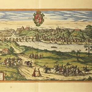
Canvas Print : Map of Genoa and Florence from Civitates Orbis Terrarum by Georg Braun, 1541-1622 and Franz Hogenberg, 1540-1590, engraving


![]()
Canvas Prints from Universal Images Group (UIG)
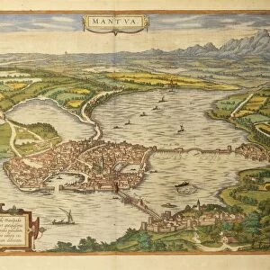
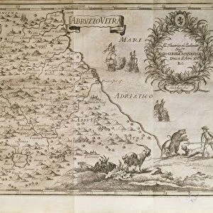
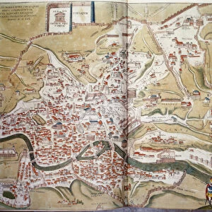
Map of Genoa and Florence from Civitates Orbis Terrarum by Georg Braun, 1541-1622 and Franz Hogenberg, 1540-1590, engraving
Cartography, Italy, 16th century. Map of Genoa and Florence. From Civitates Orbis Terrarum by Georg Braun (1541-1622) and Franz Hogenberg (1540-1590), Cologne. Engraving
Universal Images Group (UIG) manages distribution for many leading specialist agencies worldwide
Media ID 9505333
© DEA / R. MERLO
16th Century Book Florence Genoa Horizon Over Land Manuscript Mountain River Sailing Boat Townscape
20"x16" (51x41cm) Canvas Print
Step back in time with our exquisite Canvas Print of the Map of Genoa and Florence, taken from the renowned Civitates Orbis Terrarum atlas. This 16th-century engraving, created by the masterful hands of Georg Braun and Franz Hogenberg, provides a captivating glimpse into the cartography of Italy during that era. With intricate detail and vibrant colors, this art piece is a must-have for history enthusiasts, cartography collectors, or anyone who appreciates the beauty of historical maps. Bring the rich history of this period into your home or office with our high-quality Canvas Print.
Delivered stretched and ready to hang our premium quality canvas prints are made from a polyester/cotton blend canvas and stretched over a 1.25" (32mm) kiln dried knot free wood stretcher bar. Packaged in a plastic bag and secured to a cardboard insert for safe transit.
Canvas Prints add colour, depth and texture to any space. Professionally Stretched Canvas over a hidden Wooden Box Frame and Ready to Hang
Estimated Product Size is 50.8cm x 40.6cm (20" x 16")
These are individually made so all sizes are approximate
Artwork printed orientated as per the preview above, with landscape (horizontal) orientation to match the source image.
FEATURES IN THESE COLLECTIONS
> Arts
> Art Movements
> Landscapes
> Arts
> Artists
> H
> Franz Hogenberg
> Arts
> Contemporary art
> Landscapes
> Mountain landscapes
> Arts
> Landscape paintings
> Landscape art
> Mountain landscapes
> Arts
> Landscape paintings
> Landscape art
> Arts
> Landscape paintings
> Waterfall and river artworks
> Landscape paintings
> Arts
> Landscape paintings
> Waterfall and river artworks
> Europe
> France
> Canton
> Landes
> Universal Images Group (UIG)
> Art
> Painting, Sculpture & Prints
> Cartography
EDITORS COMMENTS
This print showcases a remarkable piece of cartographic history, featuring the Map of Genoa and Florence from Civitates Orbis Terrarum by Georg Braun and Franz Hogenberg. Created in the 16th century, this engraving offers a glimpse into Italy's rich past. The intricate details captured in this studio shot transport us back to an era when maps were meticulously crafted by hand. The mountainous landscape of Italy serves as a majestic backdrop, while the townscape reveals the architectural beauty of both Genoa and Florence. As we explore this historical artifact, our eyes are drawn to a sailing boat gracefully navigating its way along the river. This small element adds depth and movement to an otherwise still image, reminding us of Italy's strong maritime heritage. The manuscript-like quality of this print evokes a sense of reverence for knowledge and exploration during that time period. It is evident that every stroke was carefully etched onto paper with precision and dedication. With no people present in the scene, our focus shifts towards appreciating the artistry behind this map. The horizontal composition allows us to fully immerse ourselves in its vastness, while also highlighting important geographical features such as rivers and land horizons. Overall, this print not only captures a moment frozen in time but also invites us to delve into centuries-old stories woven within its lines.
MADE IN AUSTRALIA
Safe Shipping with 30 Day Money Back Guarantee
FREE PERSONALISATION*
We are proud to offer a range of customisation features including Personalised Captions, Color Filters and Picture Zoom Tools
SECURE PAYMENTS
We happily accept a wide range of payment options so you can pay for the things you need in the way that is most convenient for you
* Options may vary by product and licensing agreement. Zoomed Pictures can be adjusted in the Cart.