Home > Arts > Artists > H > Franz Hogenberg
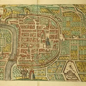
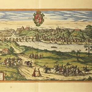
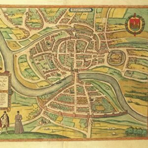
Map of Cambrai from Civitates Orbis Terrarum by Georg Braun, 1541-1622 and Franz Hogenberg, 1540-1590, engraving

![]()
Wall Art and Photo Gifts from Universal Images Group (UIG)
Map of Cambrai from Civitates Orbis Terrarum by Georg Braun, 1541-1622 and Franz Hogenberg, 1540-1590, engraving
Cartography, France, 16th century. Map of Cambrai. From Civitates Orbis Terrarum by Georg Braun (1541-1622) and Franz Hogenberg (1540-1590), Cologne. Engraving
Universal Images Group (UIG) manages distribution for many leading specialist agencies worldwide
Media ID 9572795
© DEA / R. MERLO
16th Century Cloud Coat Of Arms Dirt Track Elevated View Horizon Over Land Latin Script Manuscript Townscape Cambrai
FEATURES IN THESE COLLECTIONS
> Arts
> Art Movements
> Landscapes
> Arts
> Artists
> H
> Franz Hogenberg
> Arts
> Contemporary art
> Landscapes
> Sculptures
> Arts
> Contemporary art
> Sculpture
> Landscape paintings
> Arts
> Landscape paintings
> Landscape art
> Landscape paintings
> Arts
> Landscape paintings
> Landscape art
> Universal Images Group (UIG)
> Art
> Painting, Sculpture & Prints
> Cartography
EDITORS COMMENTS
This print showcases a remarkable piece of cartographic history - the Map of Cambrai from Civitates Orbis Terrarum, created by Georg Braun and Franz Hogenberg in the 16th century. The engraving, meticulously crafted with intricate details, transports us back to a time when maps were not just navigational tools but also works of art. The map depicts the charming town of Cambrai in France, offering a glimpse into its physical geography and townscape during this period. From an elevated view, we can observe the landscape dotted with dirt tracks that wind through the picturesque surroundings. The horizon over land extends as far as our eyes can see, evoking a sense of vastness and exploration. Notably, the coat of arms adorns this historical masterpiece, symbolizing the significance and pride associated with Cambrai's heritage. The Latin script accompanying various elements on the map adds an air of authenticity and scholarly importance. Displayed against a cloud backdrop in this studio shot photograph, every line and stroke is accentuated for us to appreciate both its artistic value and historical relevance. While there are no people depicted within this artwork itself, it serves as a testament to human representation through meticulous craftsmanship. This print is more than just an illustration or painting; it is an invitation to delve into centuries-old cartography while marveling at how our understanding of geography has evolved over time.
MADE IN AUSTRALIA
Safe Shipping with 30 Day Money Back Guarantee
FREE PERSONALISATION*
We are proud to offer a range of customisation features including Personalised Captions, Color Filters and Picture Zoom Tools
SECURE PAYMENTS
We happily accept a wide range of payment options so you can pay for the things you need in the way that is most convenient for you
* Options may vary by product and licensing agreement. Zoomed Pictures can be adjusted in the Cart.