Canvas Print > Arts > Artists > O > Abraham Ortelius
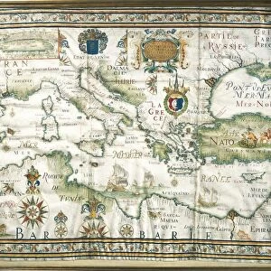
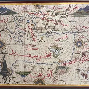
Canvas Print : Map of the Nile Delta and of ancient city of Carthage, from Theatrum Orbis Terrarum by Abraham Ortelius, 1528-1598, Antwerp, 1570


![]()
Canvas Prints from Universal Images Group (UIG)
Map of the Nile Delta and of ancient city of Carthage, from Theatrum Orbis Terrarum by Abraham Ortelius, 1528-1598, Antwerp, 1570
Cartography, 16th century. Map of the Nile Delta and of ancient city of Carthage, from Theatrum Orbis Terrarum by Abraham Ortelius (1528-1598), Antwerp, 1570
Universal Images Group (UIG) manages distribution for many leading specialist agencies worldwide
Media ID 9570615
© DEA / A. DAGLI ORTI
16th Century Carthage Latin Script Manuscript Nile River
20"x16" (51x41cm) Canvas Print
Step back in time with our exquisite Canvas Print of the Map of the Nile Delta and ancient city of Carthage, from Theatrum Orbis Terrarum by Abraham Ortelius. This 16th-century masterpiece, published in Antwerp in 1570, showcases intricate details of the geography and ancient civilizations of the region. The vibrant colors and textures of our Canvas Print bring this historical map to life, making it an impressive addition to any home or office. Experience the rich history and cartographic innovation of this rare and beautiful piece, expertly reproduced on high-quality canvas.
Delivered stretched and ready to hang our premium quality canvas prints are made from a polyester/cotton blend canvas and stretched over a 1.25" (32mm) kiln dried knot free wood stretcher bar. Packaged in a plastic bag and secured to a cardboard insert for safe transit.
Canvas Prints add colour, depth and texture to any space. Professionally Stretched Canvas over a hidden Wooden Box Frame and Ready to Hang
Estimated Product Size is 40.6cm x 50.8cm (16" x 20")
These are individually made so all sizes are approximate
Artwork printed orientated as per the preview above, with portrait (vertical) orientation to match the source image.
FEATURES IN THESE COLLECTIONS
> Animals
> Fishes
> G
> Grouper
> Arts
> Artists
> O
> Abraham Ortelius
> Arts
> Landscape paintings
> Waterfall and river artworks
> River artworks
> Maps and Charts
> Abraham Ortelius
> Maps and Charts
> Early Maps
> Maps and Charts
> Related Images
> Universal Images Group (UIG)
> Art
> Painting, Sculpture & Prints
> Cartography
EDITORS COMMENTS
This print showcases a remarkable piece of cartographic history - the Map of the Nile Delta and ancient city of Carthage. Created by Abraham Ortelius, a renowned Flemish cartographer from Antwerp in the late 16th century, this map is an exquisite example of his influential work. Ortelius's masterpiece, featured in Theatrum Orbis Terrarum, takes us on a journey through time and space. With intricate detail and precision, he beautifully captures the physical geography of the Nile Delta region as well as the ancient city of Carthage. This map serves as both an invaluable historical document and a stunning piece of art. The composition is horizontal, allowing viewers to immerse themselves in every minute detail presented before them. Through careful brushstrokes and delicate use of color, Ortelius breathes life into this illustration. The Latin script adds an air of authenticity to this manuscript-like creation. As we gaze upon this image, we are transported back to a time when exploration was at its peak. It reminds us that maps were not just tools for navigation but also works of art that celebrated human curiosity about our world. In this particular rendition from Universal Images Group (UIG), no people are present; instead, it focuses solely on showcasing the magnificence and significance behind Ortelius's creation. Let this photograph print serve as a reminder that even centuries later, these historical artifacts continue to captivate our imagination with their timeless beauty.
MADE IN AUSTRALIA
Safe Shipping with 30 Day Money Back Guarantee
FREE PERSONALISATION*
We are proud to offer a range of customisation features including Personalised Captions, Color Filters and Picture Zoom Tools
SECURE PAYMENTS
We happily accept a wide range of payment options so you can pay for the things you need in the way that is most convenient for you
* Options may vary by product and licensing agreement. Zoomed Pictures can be adjusted in the Cart.