Home > Universal Images Group (UIG) > Art > Painting, Sculpture & Prints > Cartography
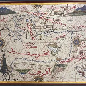
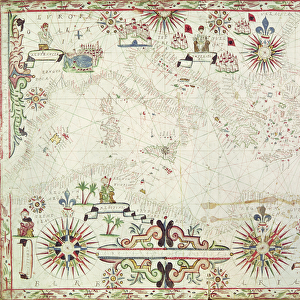
Mediterranean Sea, from portolan atlas of six charts, by Placido Caloiro and Francesco Oliva, Parchment. 1646

![]()
Wall Art and Photo Gifts from Universal Images Group (UIG)
Mediterranean Sea, from portolan atlas of six charts, by Placido Caloiro and Francesco Oliva, Parchment. 1646
Cartography, 17th century. The Mediterranean Sea, from a portolan atlas of six charts, by Placido Caloiro and Francesco Oliva, 1646. Parchment
Universal Images Group (UIG) manages distribution for many leading specialist agencies worldwide
Media ID 9500467
© DEA / A. DAGLI ORTI
17th Century Caloiro Placido Mediterranean Sea Oliva Francesco
EDITORS COMMENTS
This print showcases a remarkable piece of cartographic history, the Mediterranean Sea, from a portolan atlas of six charts by Placido Caloiro and Francesco Oliva. Created in 1646 on parchment, this antique map takes us back to the 17th century when exploration and navigation were at their peak. The intricate details depicted on this horizontal illustration are truly awe-inspiring. Every curve of the coastline, every island, and even the smallest harbor is meticulously captured with precision and artistry. The map's vibrant colors bring life to the vast expanse of the Mediterranean Sea, inviting viewers to embark on an imaginary journey through its waters. As we gaze upon this historical artifact, it is impossible not to marvel at the skill and dedication required to produce such a masterpiece. This work exemplifies the expertise of Caloiro and Oliva in their craft as they sought to document geographical knowledge during their time. While devoid of people or any modern landmarks that we may be accustomed to seeing on contemporary maps, this image transports us back centuries ago when sailors relied solely on these hand-drawn guides for navigation across treacherous seas. This print serves as a testament to our fascination with history and our enduring curiosity about how our ancestors perceived and explored our world. It reminds us that even in today's digital age, there is still immense value in preserving tangible artifacts like this one – windows into our past that continue to captivate us with their beauty and significance.
MADE IN AUSTRALIA
Safe Shipping with 30 Day Money Back Guarantee
FREE PERSONALISATION*
We are proud to offer a range of customisation features including Personalised Captions, Color Filters and Picture Zoom Tools
SECURE PAYMENTS
We happily accept a wide range of payment options so you can pay for the things you need in the way that is most convenient for you
* Options may vary by product and licensing agreement. Zoomed Pictures can be adjusted in the Cart.