Home > Europe > France > Paris > Maps
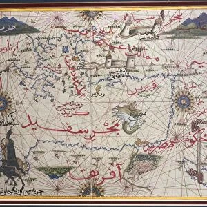
Map of the Mediterranean, 1625 (gouache on paper)
")
![]()
Wall Art and Photo Gifts from Fine Art Finder
Map of the Mediterranean, 1625 (gouache on paper)
XIR187095 Map of the Mediterranean, 1625 (gouache on paper) by Oliva, Johannes (fl.1625) (attr. to); Bibliotheque Nationale, Paris, France; Spanish, out of copyright
Media ID 12748680
© www.bridgemanimages.com
FEATURES IN THESE COLLECTIONS
> Arts
> Artists
> Related Images
> Europe
> France
> Paris
> Maps
> Fine Art Finder
> Maps (celestial & Terrestrial)
EDITORS COMMENTS
This print showcases a stunning piece of cartographic art, the "Map of the Mediterranean, 1625" by Johannes Oliva. Created using gouache on paper, this masterpiece takes us back in time to the 17th century when exploration and navigation were at their peak. The intricate details and vibrant colors bring life to this historical depiction of the Mediterranean Sea. As we gaze upon this map, our eyes are drawn to the various countries and cities that line its shores. From Spain to Greece, from Italy to Morocco, every corner is meticulously illustrated with accuracy and precision. The artist's skillful hand has beautifully captured not only geographical features but also cultural landmarks that dot this ancient landscape. The presence of a compass adds an element of intrigue and adventure to the composition. It reminds us of the brave sailors who relied on such tools as they embarked on perilous voyages across these treacherous waters centuries ago. Displayed against a backdrop reminiscent of aged parchment, this print exudes an air of nostalgia and reverence for history. It serves as a reminder that maps hold more than just geographic information; they embody stories of exploration, conquests, trade routes, and civilizations long past. With its timeless appeal and artistic excellence, "Map of the Mediterranean" transports us into a world where imagination meets reality—a world waiting to be discovered through both landfall and sea voyage alike.
MADE IN AUSTRALIA
Safe Shipping with 30 Day Money Back Guarantee
FREE PERSONALISATION*
We are proud to offer a range of customisation features including Personalised Captions, Color Filters and Picture Zoom Tools
SECURE PAYMENTS
We happily accept a wide range of payment options so you can pay for the things you need in the way that is most convenient for you
* Options may vary by product and licensing agreement. Zoomed Pictures can be adjusted in the Cart.