
Canvas Print > Universal Images Group (UIG) > Universal Images Group > Satellite and Aerial > Planet Observer 4
Canvas Print : Province of Quebec, Canada, Relief Map


![]()
Canvas Prints from Universal Images Group (UIG)
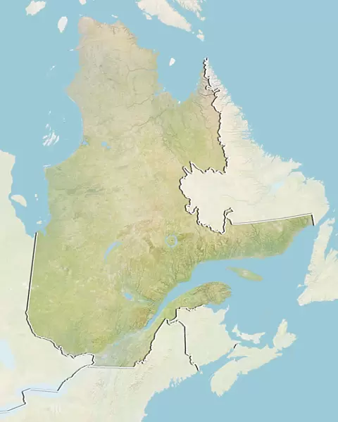
Province of Quebec, Canada, Relief Map
Relief map of Quebec, Canada. This image was compiled from data acquired by LANDSAT 5 & 7 satellites combined with elevation data
Universal Images Group (UIG) manages distribution for many leading specialist agencies worldwide
Media ID 9619275
© Planet Observer/UIG
Canada Coastline Lake Montreal Province Quebec Relief Map Shore Saint Lawrence River Satellite View
20"x16" (51x41cm) Canvas Print
Discover the beauty and complexity of the Province of Quebec, Canada, with our stunning Canvas Prints from Media Storehouse. This captivating image, sourced from Universal Images Group (UIG), showcases a relief map of Quebec meticulously compiled from LANDSAT 5 & 7 satellite data and elevation information. Bring the intricate topography of Quebec into your home or office, enhancing any space with an allure of geographic wonder. Experience the crisp details and vibrant colors that our Canvas Prints are renowned for, making this an ideal gift for map enthusiasts, geography educators, or anyone who appreciates the natural wonders of Canada.
Delivered stretched and ready to hang our premium quality canvas prints are made from a polyester/cotton blend canvas and stretched over a 1.25" (32mm) kiln dried knot free wood stretcher bar. Packaged in a plastic bag and secured to a cardboard insert for safe transit.
Canvas Prints add colour, depth and texture to any space. Professionally Stretched Canvas over a hidden Wooden Box Frame and Ready to Hang
Estimated Product Size is 40.6cm x 50.8cm (16" x 20")
These are individually made so all sizes are approximate
Artwork printed orientated as per the preview above, with portrait (vertical) orientation to match the source image.
EDITORS COMMENTS
This stunning print showcases the breathtaking province of Quebec, Canada, in all its natural glory. The relief map captures the diverse topography and physical geography of this enchanting region, providing a visual feast for the eyes. Compiled from data acquired by LANDSAT 5 & 7 satellites combined with elevation data, this image offers an accurate representation of Quebec's landscape. The vibrant colors and intricate details bring to life the majestic Saint Lawrence River as it winds its way through the province. From the bustling cityscape of Montreal to the serene shorelines that dot the coastline, every aspect is beautifully depicted in this vertical photograph. As you explore this map, you can't help but marvel at Quebec's rich natural beauty. The varying elevations and contours reveal mountains, valleys, lakes, and rivers that contribute to its unique charm. This print not only serves as a testament to Quebec's geographical diversity but also highlights its importance in North America. With no people present in this image, it allows us to focus solely on appreciating nature's wonders without any distractions. Whether you are a cartography enthusiast or simply someone who admires awe-inspiring landscapes, this print is sure to captivate your imagination
MADE IN AUSTRALIA
Safe Shipping with 30 Day Money Back Guarantee
FREE PERSONALISATION*
We are proud to offer a range of customisation features including Personalised Captions, Color Filters and Picture Zoom Tools
SECURE PAYMENTS
We happily accept a wide range of payment options so you can pay for the things you need in the way that is most convenient for you
* Options may vary by product and licensing agreement. Zoomed Pictures can be adjusted in the Cart.