Canvas Print > Europe > United Kingdom > England > Sussex > Cowfold
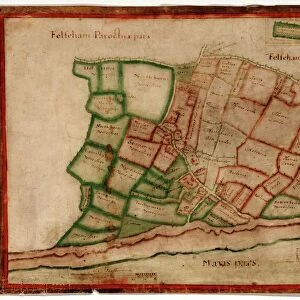
Canvas Print : Cowfold tithe map, 1840


![]()
Canvas Prints from West Sussex County Council
Cowfold tithe map, 1840
By William Duncum, Reading, Berks. 26.6 in. to 1 m. 104 × 92
Tithe Award Map Collection
West Sussex Record Office Ref No: TD/W154
West Sussex County Council Record Office contains a fascinating history of the county of West Sussex, England
Media ID 10702218
© West Sussex County Council - All Rights Reserved
1840s 19th Century Historical Mapping South Of England
20"x16" (51x41cm) Canvas Print
Discover the rich history of West Sussex with our exquisite Canvas Prints from Media Storehouse. This particular print showcases an intriguing piece from the past - the Cowfold Tithe Map of 1840. Originally created by William Duncum, this detailed and captivating map is part of the TD/W154 Tithe Award Map Collection at the West Sussex Record Office. Bring the history of Cowfold directly into your home or office with our high-quality Canvas Prints. Preserve the past while adding a touch of timeless charm to your surroundings.
Delivered stretched and ready to hang our premium quality canvas prints are made from a polyester/cotton blend canvas and stretched over a 1.25" (32mm) kiln dried knot free wood stretcher bar. Packaged in a plastic bag and secured to a cardboard insert for safe transit.
Canvas Prints add colour, depth and texture to any space. Professionally Stretched Canvas over a hidden Wooden Box Frame and Ready to Hang
Estimated Product Size is 40.6cm x 50.8cm (16" x 20")
These are individually made so all sizes are approximate
Artwork printed orientated as per the preview above, with portrait (vertical) orientation to match the source image.
FEATURES IN THESE COLLECTIONS
> Europe
> United Kingdom
> England
> Maps
> Europe
> United Kingdom
> England
> Sussex
> Cowfold
> Europe
> United Kingdom
> England
> Sussex
> Related Images
> Europe
> United Kingdom
> England
> West Sussex
> Related Images
> Maps and Charts
> Early Maps
> Maps and Charts
> Related Images
> West Sussex County Council
> West Sussex Record Office
> Tithe Award Maps, 1808-1859
EDITORS COMMENTS
This print showcases the historic Cowfold tithe map, meticulously crafted by William Duncum in 1840. With its impressive scale of 26.6 inches to 1 meter and dimensions measuring an astounding 104 by 92 inches, this map offers a fascinating glimpse into the past. Housed within the esteemed Tithe Award Map Collection at West Sussex Record Office, it stands as a testament to the rich history of the South of England during the mid-19th century. The Cowfold tithe map is a treasure trove for historians and enthusiasts alike, providing invaluable insights into land ownership and usage patterns from that era. Its intricate details reveal every nook and cranny of this rural landscape, capturing farms, fields, roads, and boundaries with remarkable precision. Preserved by West Sussex County Council with reference number TD/W154, this print serves as a window to our heritage without any commercial intentions. It invites viewers to immerse themselves in the historical mapping techniques employed centuries ago while appreciating how much our surroundings have evolved over time. As we gaze upon this remarkable piece of cartographic artistry created by William Duncum all those years ago in Reading, Berks. , let us marvel at its beauty and significance in documenting an important chapter in local history.
MADE IN AUSTRALIA
Safe Shipping with 30 Day Money Back Guarantee
FREE PERSONALISATION*
We are proud to offer a range of customisation features including Personalised Captions, Color Filters and Picture Zoom Tools
SECURE PAYMENTS
We happily accept a wide range of payment options so you can pay for the things you need in the way that is most convenient for you
* Options may vary by product and licensing agreement. Zoomed Pictures can be adjusted in the Cart.