Cushion > Fine Art Storehouse > Map
Cushion : 1697, antiquity, archival, cartography, england, europe, geographical, geography


![]()
Home Decor from Fine Art Storehouse
1697, antiquity, archival, cartography, england, europe, geographical, geography
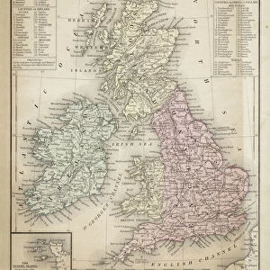
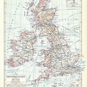
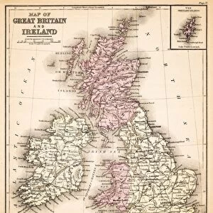
1697, antiquity, archival, cartography, england, europe, geographical, geography, great britain, historical, ireland, map, nobody, north ireland, north sea, old-fashioned, scotland, text, uk, vintage, Antique Maps, 89687331
Unleash your creativity and transform your space into a visual masterpiece!
Hemera Technologies
Media ID 14761240
© Getty Images
Antiquity Geographical Geography Great Britain Ireland North Sea Scotland Text 1697 North Ireland
Cushion
Refresh your home decor with a beautiful full photo 16"x16" (40x40cm) cushion, complete with cushion pad insert. Printed on both sides and made from 100% polyester with a zipper on the bottom back edge of the cushion cover. Care Instructions: Warm machine wash, do not bleach, do not tumble dry. Warm iron inside out. Do not dry clean.
Accessorise your space with decorative, soft cushions
Estimated Product Size is 40cm x 40cm (15.7" x 15.7")
These are individually made so all sizes are approximate
Artwork printed orientated as per the preview above, with landscape (horizontal) or portrait (vertical) orientation to match the source image.
FEATURES IN THESE COLLECTIONS
> Fine Art Storehouse
> Map
> Historical Maps
EDITORS COMMENTS
This print takes us back in time to the year 1697, immersing us in the rich antiquity of England and Europe. With its intricate cartography and detailed geographical features, this archival map offers a glimpse into the past, showcasing Great Britain, Ireland, Scotland, and even North Sea regions. The vintage charm of this old-fashioned piece is truly remarkable. As we explore this historical treasure, our eyes are drawn to the carefully crafted text that accompanies each landmark on the map. It serves as a testament to the meticulous craftsmanship of cartographers from centuries ago. This print not only captures an era long gone but also reminds us of how far we have come in terms of understanding our world's geography. The absence of any human presence allows us to fully appreciate the sheer beauty and complexity of nature's design. From rolling hills to vast bodies of water like North Sea, every element on this map tells a story waiting to be discovered. Whether you are an avid collector or simply fascinated by history and geography, this antique map print will undoubtedly add a touch of sophistication and intrigue to any space it graces. Let your imagination wander as you delve into the mysteries hidden within these meticulously inked lines – a true masterpiece by Hemera Technologies from Fine Art Storehouse.
MADE IN AUSTRALIA
Safe Shipping with 30 Day Money Back Guarantee
FREE PERSONALISATION*
We are proud to offer a range of customisation features including Personalised Captions, Color Filters and Picture Zoom Tools
SECURE PAYMENTS
We happily accept a wide range of payment options so you can pay for the things you need in the way that is most convenient for you
* Options may vary by product and licensing agreement. Zoomed Pictures can be adjusted in the Cart.