Cushion > Africa > South Africa > Maps
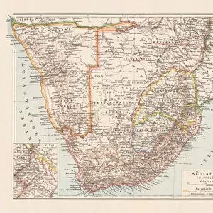
Cushion : Antique map of South Africa, 1884, 19th Century


![]()
Home Decor from Fine Art Storehouse
Antique map of South Africa, 1884, 19th Century
Vintage engraving of Antique map of South Africa, 1884, 19th Century
Unleash your creativity and transform your space into a visual masterpiece!
duncan1890
Media ID 18563436
Cushion
Refresh your home decor with a beautiful full photo 16"x16" (40x40cm) cushion, complete with cushion pad insert. Printed on both sides and made from 100% polyester with a zipper on the bottom back edge of the cushion cover. Care Instructions: Warm machine wash, do not bleach, do not tumble dry. Warm iron inside out. Do not dry clean.
Accessorise your space with decorative, soft cushions
Estimated Product Size is 40cm x 40cm (15.7" x 15.7")
These are individually made so all sizes are approximate
Artwork printed orientated as per the preview above, with landscape (horizontal) or portrait (vertical) orientation to match the source image.
FEATURES IN THESE COLLECTIONS
> Africa
> Related Images
> Africa
> South Africa
> Maps
> Africa
> South Africa
> Related Images
> Maps and Charts
> Related Images
> Fine Art Storehouse
> Map
> Historical Maps
EDITORS COMMENTS
This print showcases an exquisite antique map of South Africa, dating back to the year 1884. A true relic from the 19th century, this vintage engraving takes us on a journey through time and space, offering a glimpse into the cartographic wonders of yesteryears. The intricate details and delicate craftsmanship displayed in this piece are nothing short of remarkable. As we gaze upon this mesmerizing artwork, our eyes are drawn to the fine lines and precise markings that depict the vast landscapes and geographical features of South Africa. Every contour is meticulously etched onto paper, capturing the essence of exploration and discovery that characterized this era. The antiquity exuded by this map transports us back to a time when cartography was both an art form and a scientific endeavor. It reminds us of the meticulous efforts made by early explorers who ventured into uncharted territories armed with little more than their instruments and unwavering curiosity. With its warm sepia tones, this print evokes nostalgia for a bygone era while simultaneously celebrating the rich history embedded within each stroke. It serves as a testament to human ingenuity and resilience in their quest for knowledge about our world. Duncan1890's masterful capture allows us to appreciate not only the beauty but also the historical significance behind this antique map. As it graces any wall or display, it becomes more than just an image; it becomes a gateway to unraveling stories from centuries past – tales waiting patiently for curious minds to explore them once
MADE IN AUSTRALIA
Safe Shipping with 30 Day Money Back Guarantee
FREE PERSONALISATION*
We are proud to offer a range of customisation features including Personalised Captions, Color Filters and Picture Zoom Tools
SECURE PAYMENTS
We happily accept a wide range of payment options so you can pay for the things you need in the way that is most convenient for you
* Options may vary by product and licensing agreement. Zoomed Pictures can be adjusted in the Cart.