Cushion > Europe > France > Paris > Maps
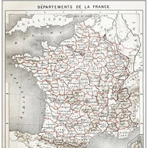
Cushion : France Waterways map 1887


![]()
Home Decor from Fine Art Storehouse
France Waterways map 1887
Map from La Premiere Annee de Geographie par P. Foncin - Paris 1887
Unleash your creativity and transform your space into a visual masterpiece!
THEPALMER
Media ID 20132945
© A 2014 Roberto Adrian Photography
Cushion
Refresh your home decor with a beautiful full photo 16"x16" (40x40cm) cushion, complete with cushion pad insert. Printed on both sides and made from 100% polyester with a zipper on the bottom back edge of the cushion cover. Care Instructions: Warm machine wash, do not bleach, do not tumble dry. Warm iron inside out. Do not dry clean.
Accessorise your space with decorative, soft cushions
Estimated Product Size is 40cm x 40cm (15.7" x 15.7")
These are individually made so all sizes are approximate
Artwork printed orientated as per the preview above, with landscape (horizontal) or portrait (vertical) orientation to match the source image.
FEATURES IN THESE COLLECTIONS
> Europe
> France
> Paris
> Maps
> Europe
> France
> Paris
> Related Images
> Maps and Charts
> Related Images
> Fine Art Storehouse
> Map
> Historical Maps
EDITORS COMMENTS
This print showcases a vintage treasure, the "France Waterways map 1887" sourced from the esteemed collection of Fine Art Storehouse. A true testament to the artistry and precision of cartography, this map was originally published in Paris in 1887 as part of "La Premiere Annee de Geographie" by P. Foncin. Transporting us back in time, this meticulously detailed map offers a glimpse into France's intricate network of waterways during the late 19th century. Every river, canal, and tributary is intricately depicted with remarkable accuracy, showcasing the nation's vital lifelines that facilitated trade and transportation across its diverse regions. The aged aesthetic adds a touch of nostalgia to this print; one can almost imagine tracing their fingers along each delicate line etched on yellowed parchment. The rich hues and fine craftsmanship are beautifully preserved through careful restoration by THEPALMER. Whether you're an avid history enthusiast or simply appreciate exquisite artwork, this stunning piece will undoubtedly captivate your imagination. It serves as both an educational tool for understanding France's historical geography and a visual delight for those seeking unique decor options. Display it proudly on your wall or gift it to someone who shares your passion for exploration and heritage. This timeless masterpiece invites you to embark on a journey through France's enchanting waterways while celebrating the beauty found within antique maps – truly an extraordinary addition to any art collection.
MADE IN AUSTRALIA
Safe Shipping with 30 Day Money Back Guarantee
FREE PERSONALISATION*
We are proud to offer a range of customisation features including Personalised Captions, Color Filters and Picture Zoom Tools
SECURE PAYMENTS
We happily accept a wide range of payment options so you can pay for the things you need in the way that is most convenient for you
* Options may vary by product and licensing agreement. Zoomed Pictures can be adjusted in the Cart.