Cushion > North America > United States of America > New York > New York > Maps
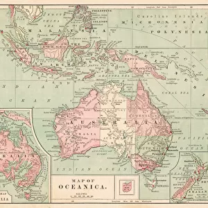
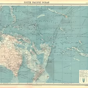
Cushion : Map of Australia 1877


![]()
Home Decor from Fine Art Storehouse
Map of Australia 1877
The Eclectic Elementary Geography by Wilson & Hinkle / Cincinnati -New York 1881
Unleash your creativity and transform your space into a visual masterpiece!
THEPALMER
Media ID 15380691
© This content is subject to copyright
Australasia Australia Indonesia Malaysia New Zealand Oceania Pacific Papua Solomon Tasmania
Cushion
Refresh your home decor with a beautiful full photo 16"x16" (40x40cm) cushion, complete with cushion pad insert. Printed on both sides and made from 100% polyester with a zipper on the bottom back edge of the cushion cover. Care Instructions: Warm machine wash, do not bleach, do not tumble dry. Warm iron inside out. Do not dry clean.
Accessorise your space with decorative, soft cushions
Estimated Product Size is 40cm x 40cm (15.7" x 15.7")
These are individually made so all sizes are approximate
Artwork printed orientated as per the preview above, with landscape (horizontal) or portrait (vertical) orientation to match the source image.
FEATURES IN THESE COLLECTIONS
> Arts
> Artists
> W
> Wilson Wilson
> Asia
> Indonesia
> Related Images
> Asia
> Malaysia
> Related Images
> Maps and Charts
> Related Images
> North America
> United States of America
> New York
> New York
> Maps
> North America
> United States of America
> New York
> Related Images
> Fine Art Storehouse
> Map
> Historical Maps
EDITORS COMMENTS
This print showcases a historical treasure, the "Map of Australia 1877" taken from "The Eclectic Elementary Geography" by Wilson & Hinkle in Cincinnati-New York 1881. The map offers a fascinating glimpse into the past, depicting the vast expanse of Australia and its surrounding regions during that era. With intricate details and vibrant colors, this artwork transports us back to a time when Malaysia, Tasmania, Australasia, Indonesia, New Zealand, Oceania, Pacific Islands including Papua and Solomon were all part of this magnificent continent's narrative. It serves as a visual testament to the rich history and diverse geography that shaped Australia's identity. "The Map of Australia 1877" is not just an ordinary cartographic representation; it encapsulates an entire era's exploration and discovery. Its presence on display ignites curiosity about how early explorers navigated these uncharted territories with limited resources. As we admire this piece by THEPALMER from Fine Art Storehouse, we are reminded of the profound beauty found within historical artifacts. This photograph print allows us to appreciate both the artistry behind creating such maps as well as their significance in preserving our collective heritage. Whether you're an avid historian or simply captivated by vintage aesthetics, this print will undoubtedly transport you through time while adding a touch of elegance to any space it graces.
MADE IN AUSTRALIA
Safe Shipping with 30 Day Money Back Guarantee
FREE PERSONALISATION*
We are proud to offer a range of customisation features including Personalised Captions, Color Filters and Picture Zoom Tools
SECURE PAYMENTS
We happily accept a wide range of payment options so you can pay for the things you need in the way that is most convenient for you
* Options may vary by product and licensing agreement. Zoomed Pictures can be adjusted in the Cart.