Fraud Blocker Skip to main content

Upperthorpe Collection

Upperthorpe, a historic neighborhood in Sheffield, is steeped in rich history and charm

Background imageUpperthorpe Collection: Crookesmoor School, Sheffield, 1874

Crookesmoor School, Sheffield, 1874
From an original at Sheffield Libraries: s06501

Background imageUpperthorpe Collection: Sheffield Royal Infirmary Chapel, Infirmary Road, Sheffield, c. 1910

Sheffield Royal Infirmary Chapel, Infirmary Road, Sheffield, c. 1910
From an original at Sheffield Libraries: p00114

Background imageUpperthorpe Collection: Plan of part of the townships of Sheffield and Nether Hallam, Sheffield, c. 1826

Plan of part of the townships of Sheffield and Nether Hallam, Sheffield, c. 1826
Full title: Plan of part of the townships of Sheffield and Nether Hallam which is in dispute. Includes John Addys house, Lidgate Field, Shales Moor Close, White House Lane or Walkley Road

Background imageUpperthorpe Collection: Bond Street, Upperthorpe, Sheffield, c. 1910

Bond Street, Upperthorpe, Sheffield, c. 1910
Showing George William Womersley, Draper, Hosier, etc. From an original at Sheffield Libraries: p00116

Background imageUpperthorpe Collection: View over Netherthorpe and Upperthorpe, Sheffield, 1962

View over Netherthorpe and Upperthorpe, Sheffield, 1962
View over Netherthorpe and Upperthorpe from Crookes Valley Road showing (left) Martin Street Flats, (centre) Bromley Street and (right) Blythe Street Buildings and streets, w02746

Background imageUpperthorpe Collection: North East Derbyshire S21 1 Map

North East Derbyshire S21 1 Map
Postcode Sector Map of North East Derbyshire S21 1

Background imageUpperthorpe Collection: Sheffield S6 3 Map

Sheffield S6 3 Map
Postcode Sector Map of Sheffield S6 3

Background imageUpperthorpe Collection: Sheffield Royal Infirmary Block Plan

Sheffield Royal Infirmary Block Plan
Original at Local Studies Library: S(21)6VS

Background imageUpperthorpe Collection: land at Upperthorpe and an estate at Hollins, near Malin Bridge, in the hamlet of Stannington, 1869

land at Upperthorpe and an estate at Hollins, near Malin Bridge, in the hamlet of Stannington, 1869
Full title: Plan of freehold land at Upperthorpe and an estate at Hollins, near Malin Bridge, in the hamlet of Stannington belonging to the trustees of the will of the late Thomas Blake, esquire

Background imageUpperthorpe Collection: Plan of Freehold Estate at Crookes Moor [Crookesmoor] belonging to the executors of the late P

Plan of Freehold Estate at Crookes Moor [Crookesmoor] belonging to the executors of the late P Ashberry esquire
Scale: 30 feet : 1 inch.Surveyor: T. H. Jenkinson.Original at Sheffield Local Studiess (5) 2 L

Background imageUpperthorpe Collection: Banish wash day drudgery - advertisement for wash houses, 1939

Banish wash day drudgery - advertisement for wash houses, 1939
Image from The City of Sheffield Commercial Handbook and Illustrated Guide, 1939 (Local Studies 914.274 S)

Background imageUpperthorpe Collection: Advertisement: Weston Picture Palace cinema, Upper St Philips Road, 1915

Advertisement: Weston Picture Palace cinema, Upper St Philips Road, 1915
Showing is V.C. the great war drama.Image from Whats On in Sheffield, Vo. IV No. 70 Feb 1915 (Sheffield Local Studies Library MP 6467 M)


All Professionally Made to Order for Quick Shipping

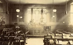
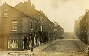
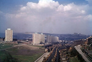
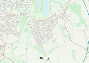
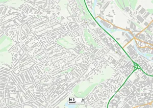
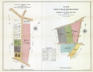
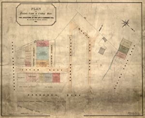
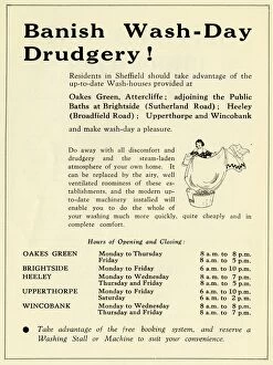
Upperthorpe, a historic neighborhood in Sheffield, is steeped in rich history and charm. Its origins can be traced back to the 19th century when Crookesmoor School was established in 1874, providing education to generations of local children. The landscape has seen many changes over the years. The Sheffield Royal Infirmary Chapel on Infirmary Road stood proudly since around 1910, offering solace and comfort to those seeking healing. A plan from 1826 reveals the layout of this vibrant township along with neighboring Nether Hallam. Bond Street, captured in a photograph from circa 1910, showcases the bustling streets and thriving community that once thrived here. Meanwhile, land at Upperthorpe and an estate at Hollins near Malin Bridge were acquired by Stannington's hamlet residents in 1869. A significant development occurred in 1881 when the executors of P Ashberry's estate laid out Crookes Moor for building purposes. This marked a turning point for Upperthorpe as it expanded its residential areas and welcomed new inhabitants. In an era where wash day drudgery was prevalent, advertisements promoting wash houses emerged in 1939 - offering respite from tedious household chores. These establishments aimed to banish the burden of laundry while fostering community spirit among residents. As time progressed into the mid-20th century, a breathtaking view over Netherthorpe and Upperthorpe showcased their architectural beauty against Sheffield's skyline in a snapshot from 1962. This image encapsulates both nostalgia for bygone days and hope for future growth. Maps depicting North East Derbyshire S21-1 and Sheffield S6-3 highlight how Upperthorpe remains an integral part of these regions' fabric - connecting communities through shared heritage.