Cushion > North America > Barbados > Maps
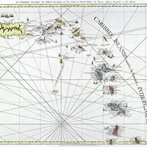
Cushion : Map of Barbados, c1758


![]()
Home Decor from Heritage Images
Map of Barbados, c1758
Heritage Images features heritage image collections
Media ID 14953434
© The Print Collector / Heritage-Images
Barbados Caribbean Cartography Colony Indies Island Map Making Print Collector21 Topographical Topography West Indian West Indies British Empire
Cushion
Refresh your home decor with a beautiful full photo 16"x16" (40x40cm) cushion, complete with cushion pad insert. Printed on both sides and made from 100% polyester with a zipper on the bottom back edge of the cushion cover. Care Instructions: Warm machine wash, do not bleach, do not tumble dry. Warm iron inside out. Do not dry clean.
Accessorise your space with decorative, soft cushions
Estimated Product Size is 40cm x 40cm (15.7" x 15.7")
These are individually made so all sizes are approximate
Artwork printed orientated as per the preview above, with landscape (horizontal) or portrait (vertical) orientation to match the source image.
FEATURES IN THESE COLLECTIONS
> Maps and Charts
> British Empire Maps
> Maps and Charts
> Related Images
> North America
> Barbados
> Maps
> North America
> Barbados
> Related Images
EDITORS COMMENTS
This print showcases a remarkable piece of history - the "Map of Barbados, c1758". Created in the 18th century by an unknown cartographer, this map offers a fascinating glimpse into the British Empire's colonial presence in the Caribbean. The vibrant colors and intricate details bring to life the geography and topography of this enchanting island. From its stunning coastline to its lush interior, every geographical feature is meticulously depicted. The map also highlights Barbados' strategic location in relation to other West Indian islands. As we explore this centuries-old map, we can't help but wonder about the historical context surrounding it. During this period, France was also vying for control over these valuable territories, adding another layer of complexity to Barbados' story. This print serves as a testament to both the artistry and significance of map-making during that era. It reminds us how maps were not merely tools for navigation but also powerful symbols of imperial power and exploration. Thanks to Heritage Images for preserving such an invaluable piece of our collective heritage. Through their dedication, we are able to appreciate and learn from these historical artifacts that connect us with our past.
MADE IN AUSTRALIA
Safe Shipping with 30 Day Money Back Guarantee
FREE PERSONALISATION*
We are proud to offer a range of customisation features including Personalised Captions, Color Filters and Picture Zoom Tools
SECURE PAYMENTS
We happily accept a wide range of payment options so you can pay for the things you need in the way that is most convenient for you
* Options may vary by product and licensing agreement. Zoomed Pictures can be adjusted in the Cart.