Cushion > Europe > Germany > Maps
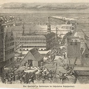
Cushion : Map of the extent of the Hanseatic League in about 1400


![]()
Home Decor from Heritage Images
Map of the extent of the Hanseatic League in about 1400
Map of the extent of the Hanseatic League in about 1400. The Hanseatic League was an alliance of about 100 north German towns and trading interests important in northern Europe from the 13th century. At the peak of its influence in the late 14th century the League enjoyed a virtual monopoly of trade in Scandinavia and the Baltic, but its power declined from the 15th century and its last Diet (assembly) met in 1669
Heritage Images features heritage image collections
Media ID 14844630
© Ann Ronan Picture Library / Heritage-Images
Baltic Sea Business Commerce Hanseatic League Merchant Ann Ronan Pictures
Cushion
Refresh your home decor with a beautiful full photo 16"x16" (40x40cm) cushion, complete with cushion pad insert. Printed on both sides and made from 100% polyester with a zipper on the bottom back edge of the cushion cover. Care Instructions: Warm machine wash, do not bleach, do not tumble dry. Warm iron inside out. Do not dry clean.
Accessorise your space with decorative, soft cushions
Estimated Product Size is 40cm x 40cm (15.7" x 15.7")
These are individually made so all sizes are approximate
Artwork printed orientated as per the preview above, with landscape (horizontal) or portrait (vertical) orientation to match the source image.
FEATURES IN THESE COLLECTIONS
> Europe
> Germany
> Related Images
> Europe
> Related Images
> Maps and Charts
> Related Images
EDITORS COMMENTS
This print showcases a detailed map of the extent of the Hanseatic League in approximately 1400. The Hanseatic League, an alliance consisting of around 100 north German towns and trading interests, played a crucial role in shaping northern Europe's economic landscape during the 13th century. At its zenith in the late 14th century, this league held a near monopoly on trade in Scandinavia and the Baltic region. The vibrant colors used to depict this historical map bring to life the extensive reach of the league's influence across various countries and regions. From Germany to Scandinavia, from bustling ports along the Baltic Sea to inland trading hubs, this visual representation highlights how commerce thrived under their governance. However, as time progressed into the 15th century, we witness a decline in power for this once mighty alliance. The last Diet or assembly meeting took place in 1669, marking an end to an era that had shaped economies and politics for centuries. As we delve into this remarkable print by Unknown (creator), it serves as a reminder of how geography played a pivotal role in shaping history. It is through maps like these that we can appreciate not only our past but also gain insights into how trade routes were established and transformed over time within Europe's dynamic commercial landscape.
MADE IN AUSTRALIA
Safe Shipping with 30 Day Money Back Guarantee
FREE PERSONALISATION*
We are proud to offer a range of customisation features including Personalised Captions, Color Filters and Picture Zoom Tools
SECURE PAYMENTS
We happily accept a wide range of payment options so you can pay for the things you need in the way that is most convenient for you
* Options may vary by product and licensing agreement. Zoomed Pictures can be adjusted in the Cart.