Home > Animals > Mammals > Muridae > Plains Mouse
Globe Asia, True Colour Satellite Image. Earth. True colour satellite image of the Earth, centred on

![]()
Wall Art and Photo Gifts from Design Pics
Globe Asia, True Colour Satellite Image. Earth. True colour satellite image of the Earth, centred on
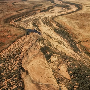
Globe Asia, True Colour Satellite Image. Earth. True colour satellite image of the Earth, centred on Asia. The North Pole is at upper centre. Water is blue, vegetation is green, arid areas are brown, and snow and ice are white. Both land and ocean floor topography are shown. The terrain of Asia varies from deserts (brown, central and southern Asia), to tropical rainforests (dark green, South East Asia), to plains, forests and tundra (lighter green, northern Asia), and mountain ranges (lower centre). Surrounding mainland Asia (clockwise from top) is the Arctic Ocean (with Greenland and North America beyond), the Pacific Ocean, the Malay Archipelago and northern Australia, the Indian Ocean, northeastern Africa, and Europe. The picture is a composite created from thousands of separate images recorded by LANDSAT 5 & 7 satellites. Print size 42x42cm
Design Pics offers Distinctively Different Imagery representing over 1,500 contributors
Media ID 24589262
© UIG / Design Pics
Asia Continent Environment Geographic Illustration Globe Satellite Image Uig Premium 1 Uig1 Satellite And Aerial World
FEATURES IN THESE COLLECTIONS
> Aerial Photography
> America
> Aerial Photography
> Australia
> Aerial Photography
> Related Images
> Africa
> South Africa
> Maps
> Africa
> South Africa
> Related Images
> Animals
> Mammals
> Muridae
> Plains Mouse
> Arts
> Artists
> O
> Oceanic Oceanic
> Arts
> Landscape paintings
> Forest and woodland scenes
> Forest artwork
> Design Pics
> Design Pics Art
> Design Pics
> Universal Images Group
> Design Pics
> Update - March 23, 2022
> Europe
> France
> Canton
> Landes
EDITORS COMMENTS
This stunning print captures the true beauty of our planet, showcasing a vivid and detailed satellite image of Earth centered on Asia. The North Pole sits majestically at the upper center, while the vibrant blue hues depict the vastness of our oceans. From lush green rainforests in Southeast Asia to arid brown deserts in central and southern regions, this image showcases the diverse terrain that Asia has to offer. The intricate topography reveals both land and ocean floor features, providing a comprehensive view of this continent. As we explore clockwise from mainland Asia, we encounter breathtaking sights such as the Arctic Ocean with Greenland and North America beyond, followed by the Pacific Ocean, Malay Archipelago with northern Australia peeking through, Indian Ocean, northeastern Africa, and finally Europe. Created from thousands of individual images recorded by LANDSAT 5 & 7 satellites, this composite offers an unparalleled perspective on our world's geography. Measuring at an impressive size of 42x42cm, it is perfect for those who appreciate both artistry and scientific accuracy. Whether you are a traveler seeking new adventures or simply fascinated by our planet's wonders from afar, this print serves as a reminder of Earth's incredible diversity and invites us to marvel at its natural splendor.
MADE IN AUSTRALIA
Safe Shipping with 30 Day Money Back Guarantee
FREE PERSONALISATION*
We are proud to offer a range of customisation features including Personalised Captions, Color Filters and Picture Zoom Tools
SECURE PAYMENTS
We happily accept a wide range of payment options so you can pay for the things you need in the way that is most convenient for you
* Options may vary by product and licensing agreement. Zoomed Pictures can be adjusted in the Cart.