Home > Animals > Mammals > Muridae > Plains Mouse
Globe North America, True Colour Satellite Image. Earth. True colour satellite image of the Earth, c

![]()
Wall Art and Photo Gifts from Design Pics
Globe North America, True Colour Satellite Image. Earth. True colour satellite image of the Earth, c
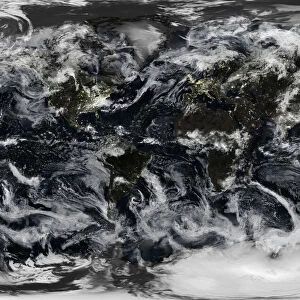
Globe North America, True Colour Satellite Image. Earth. True colour satellite image of the Earth, centred on North America. The North Pole is at upper centre. Water is blue, vegetation is green, arid areas are brown, and snow and ice are white. Both land and ocean floor topography are shown. The terrain of North America is marked by mountain ranges on the western coast, deserts in the southwest, and large lakes in the northeast. The shades of green vary, showing central plains, marshes in the far north, swamps in the southeast and forests in the northwest. Surrounding North America (clockwise from top) is the Arctic Ocean, Greenland, and the Atlantic Ocean (beyond which are Asia, Europe and Africa), South America and the Pacific Ocean. The image used data from LANDSAT 5 & 7 satellites. Print size 42x42cm
Design Pics offers Distinctively Different Imagery representing over 1,500 contributors
Media ID 24586917
© UIG / Design Pics
Continent Environment Geographic Illustration Globe Greenland Satellite Image Uig Premium 1 Uig1 Satellite And Aerial World
FEATURES IN THESE COLLECTIONS
> Aerial Photography
> America
> Aerial Photography
> Related Images
> Africa
> South Africa
> Lakes
> Related Images
> Africa
> South Africa
> Maps
> Africa
> South Africa
> Related Images
> Animals
> Mammals
> Muridae
> Plains Mouse
> Arts
> Artists
> O
> Oceanic Oceanic
> Arts
> Landscape paintings
> Forest and woodland scenes
> Forest artwork
> Design Pics
> Design Pics Art
> Design Pics
> Universal Images Group
> Design Pics
> Update - March 23, 2022
> Europe
> France
> Canton
> Landes
EDITORS COMMENTS
This stunning true-color satellite image of North America showcases the diverse and breathtaking landscapes that span this vast continent. From the majestic mountain ranges along the western coast to the arid deserts in the southwest, and from the lush forests in the northwest to the sprawling plains at its heart, North America is a tapestry of natural wonders. The image captures not only land but also ocean floor topography, providing a comprehensive view of this part of our planet. The vibrant blue hues represent water bodies, while shades of green depict vegetation covering various regions. Brown tones indicate arid areas, and white symbolizes snow and ice. At first glance, one can appreciate how North America is surrounded by vast bodies of water - to its north lies the Arctic Ocean; beyond it stretches Greenland and then comes the Atlantic Ocean connecting it with Europe, Asia, and Africa; South America borders it on its southern side alongside the Pacific Ocean. Utilizing data from LANDSAT 5 & 7 satellites allows for an accurate representation of this magnificent continent's geography. Measuring at 42x42cm in size, this print offers viewers an opportunity to marvel at Earth's beauty right from their own homes or offices. Whether you are interested in exploring Canada's wilderness or embarking on an adventure through Alaska's untamed landscapes or simply fascinated by our world's wonders – this print will surely ignite your wanderlust.
MADE IN AUSTRALIA
Safe Shipping with 30 Day Money Back Guarantee
FREE PERSONALISATION*
We are proud to offer a range of customisation features including Personalised Captions, Color Filters and Picture Zoom Tools
SECURE PAYMENTS
We happily accept a wide range of payment options so you can pay for the things you need in the way that is most convenient for you
* Options may vary by product and licensing agreement. Zoomed Pictures can be adjusted in the Cart.